Open space on southeast block shifts quarter-acre lawn to center, between mostly market-rate towers. New: homage to (demolished) Ward Bakery (!)
This is the fifth of ten articles on the 11/19/19 Quality of Life meeting, which focused on the new B12 and B13 towers. The first concerned plans to finally move forward with Site 5. The second concerned the timing of the platform over the railyard. The third concerned the single parking garage entrance on the block. The fourth concerned the design of the new towers. The sixth concerned B4, Times Plaza, and the railyard. The seventh concerned art on the Dean Street construction fence. The eighth concerned recent traffic chaos around Disney on Ice. The ninth concerned the Pacific Park Conservancy. The tenth concerned the Pacific Park Owners Association.
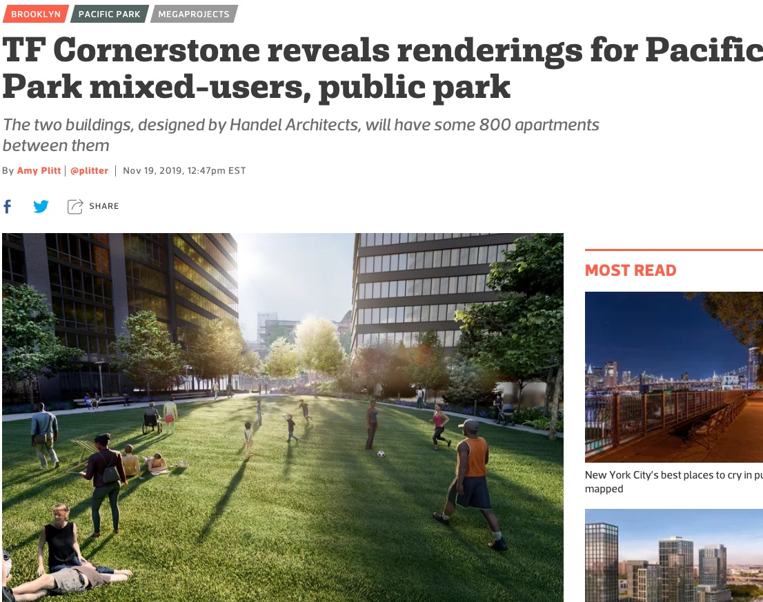
 The initial coverage, in real estate publications, focused on the green images. Curbed: TF Cornerstone reveals renderings for Pacific Park mixed-users, public park. 6sqft: New renderings show 72,600-square-foot public park coming to Brooklyn’s Pacific Park development.
Just as with the images of the buildings, as I wrote, the images of the open space distributed--both in the press materials and in the slideshow (bottom, plus screenshots)--were rather flattering.
 After all, the open space, in between towers on Dean Street, would represent 1.67 acres in total. Also, privately managed, publicly accessible open space is no "public park."
That nice broad lawn? It's a quarter of an acre, serving not just the 798 apartments directly flanking it in two towers, but (presumably) the seven towers on the southeast block, not to mention the hundreds of people visiting the Chelsea Piers field house and fitness center below ground.
Unmentioned was that there would be significant construction nearby, with likely three years (at least) to build the platform over the railyard, then several more years to build the last three towers.
Demapped Pacific Street will remain used as a service street for construction. Only when the project is finished--and master developer Greenland Forest City Partners has until 2035--would the open space be finished, and Pacific Street turned into greenery. But that's what happens when press releases drive the coverage.
A new landscape architect
The slides show the overall plan for the space, designed by Mathews Nielsen Landscape Architects (MNLA). The presenter was Stacie Ellickson, a Senior Landscape Architect. MNLA is the third announced landscape architect on the project. The master plan was done by Olin Partnership. A revision by Thomas Balsley Associates was released in 2015.
The landscape architect contributing fractional space for the two towers already on the southeast block, 535 Carlton (B14) and 550 Vanderbilt (B11), has not been not announced, but Ellickson said they aimed to take cues from the existing open space at the flanks, "so we don’t have these fragments obviously designed by different people."
The overall plan makes one big change
Below is the overall site plan. It shows the lawn as central between two towers designed in a modified "L" shape.

By contrast, below is an earlier iteration of the plan, in which B12 faced B11 and B13 faced B14.
While the presenters at the meeting did not show the slide below, contrasting Balsley's design for the southeast block with the new design, Scott Solish of Greenland USA noted that the lawn, earlier situated between the B14 and B13 towers, has been moved between B12 and B13, making it more central to the block.
Unmentioned: that also helps market-rate units: likely 75% of the apartments in B12 and B13 will be market-rate, while, B14 is "100% affordable" and already mostly leased (though it's been tough to rent the middle-income units).

"The Balsley design, as detailed as it was in his presentation, was for conceptual purposes," said Tobi Jaiyesimi of Empire State Development, noting that all landscape architecture must meet the project's established design guidelines.
 The Central open space
Ellickson said the overall plan puts more passive spaces in the center, and more active spaces in the perimeter.
Notably, a walkway below Pacific Street--which will remain used for construction staging--will connect all the parcels at the north end. That should allow people to walk from Carlton Avenue to Vanderbilt Avenue.
As noted in the image below, the central area will contain a lowland garden, a woodland garden, major walkway to the north, and, closer to Dean Street, a plaza with movable tables and chairs. Oddly, the image of the woodland garden, above right, points to the sky in the distance.

Given that the image at right showed someone kicking a soccer ball, resident Robert Puca asked what was expected.
 While it's sloped to the point where it's not suitable for active recreation, that "doesn't mean it can't be used for impromptu active space," Ellickson said.
Puca asked about keeping dogs off that lawn, given other plans for a dog run, and how to protect those lounging around from those playing ball.
Greenland's Solish said there will be additional active recreation spaces in future phases, as well as posted signs and rules. That said, they want people "to feel they have the ability to enjoy the open space without it being too dogmatic. it's got to work for everyone." He added, partly tongue in cheek (I think), "Can we not have the soccer ball in the picture?"
The East open space
The East open space includes a retail terrace behind B12 and a bike shelter near Dean Street. Moving back, there's another plaza with movable chairs, lounge chairs, amphitheater seating, and an interactive fountain. (Ellickson said, in response to a question, that the fountain water would go to vegetation.)
"We are identifying a space at northern end that we are proposing as an interpretative exhibit paying homage" to the Ward Bakery, formerly on the site, Ellickson said. It occupied much of the block, operating from 1911 to 1995 (most recently as Pechter Field), and later a fraction served for storage.
That was delivered sincerely, and it is surely on-trend to include such industrial homage, but the suggestion provoked some sardonic laughter from audience members.
Perhaps they remembered how preservation of the bakery would've been consistent with original developer Forest City Ratner's preservation plans elsewhere, or how the Landmarks Preservation Commission wouldn't preserve it.

The West open space
The western open space is the most active, Ellickson said, citing a playground and picnic grove, a destination for families to go in the summer, plus a dog run. Actually, it looks like two dog runs--small and large--and two playgrounds.
The space also will contain a backless seat wall and, undiscussed (and unexplained), "salvaged and relocated B14 chimes."

The vent structures
Both the east and west spaces will have significant ventilation structures, as described at previous meetings and approved by Empire State Development. See slide below, but note that the slide above shows the ventilation structure at the west has been moved from the playground to near the dog runs.

As I wrote in September, a Tech Memo revealed that the western structure, between B14 and B13, would be approximately 12 feet tall with an approximately 10 foot by 24 foot footprint and would be integrated into the open space.
The ventilation structure to the east, between B12 and B11, would be approximately 3 feet tall, with an approximately 25 foot by 5 foot footprint, and would be integrated into the open space’s amphitheater-style seating area.
In response to a question from resident and Community Board 6 member Pauline Blake, Ellickson stressed that the vent is on the back, and only would be activated in an emergency, by which time people would have left. There is vegetation in back.
There's also ventilation from the buildings, and later from the railyard through the platform.
Future plans
Are there any plans for community events?
Programming can be taken on by the non-profit conservancy as more parcels come on line, Jaiyesimi said.
Private events are permitted "no more than 6 to 8 times a year," Solish said.
Community concerns
Resident Peter Krashes raised the big picture: the project's overall pace, and the uncertainty about completing the final three towers, key to the major open space. "As far as I can tell, ESD can’t look at us in the eye and tell us that that open space is going to be delivered," he said.
Would a community garden be possible, asked resident Louis Galdieri.
That, said Jaiyesimi, was "something I’m sure we can consider for future parcels." It's not in any of the plans, however.
Several people asked about the conservancy. It's responsible for maintenance. It comes up with an annual budget, Solish said, and the property owners association, approves it and pays, "like a BID," or business improvement district. No public funds are involved.
"What happens if they don’t approve it?" Solish was asked.
"It's almost a pro forma vote," he responded.
The city parks department has representation on the conservancy, Jaiyesimi said. And while it's supposed to include Community Board members, neither she nor Solish had the list. She said they'd post it. (I will write soon about the conservancy and Property Owners Association.)
Others raised questions about security, and people hanging out all night. Jaiyesimi said to engage the 78th Precinct at monthly Precinct Council meetings.
Solish said the conservancy budget has line items for security and maintenance. "There will be a presence there," he said. "Also, we have to stay in contact with the local precinct."
 The initial coverage, in real estate publications, focused on the green images. Curbed: TF Cornerstone reveals renderings for Pacific Park mixed-users, public park. 6sqft: New renderings show 72,600-square-foot public park coming to Brooklyn’s Pacific Park development.
Just as with the images of the buildings, as I wrote, the images of the open space distributed--both in the press materials and in the slideshow (bottom, plus screenshots)--were rather flattering.

That nice broad lawn? It's a quarter of an acre, serving not just the 798 apartments directly flanking it in two towers, but (presumably) the seven towers on the southeast block, not to mention the hundreds of people visiting the Chelsea Piers field house and fitness center below ground.
Unmentioned was that there would be significant construction nearby, with likely three years (at least) to build the platform over the railyard, then several more years to build the last three towers.
Demapped Pacific Street will remain used as a service street for construction. Only when the project is finished--and master developer Greenland Forest City Partners has until 2035--would the open space be finished, and Pacific Street turned into greenery. But that's what happens when press releases drive the coverage.
A new landscape architect
The slides show the overall plan for the space, designed by Mathews Nielsen Landscape Architects (MNLA). The presenter was Stacie Ellickson, a Senior Landscape Architect. MNLA is the third announced landscape architect on the project. The master plan was done by Olin Partnership. A revision by Thomas Balsley Associates was released in 2015.
The landscape architect contributing fractional space for the two towers already on the southeast block, 535 Carlton (B14) and 550 Vanderbilt (B11), has not been not announced, but Ellickson said they aimed to take cues from the existing open space at the flanks, "so we don’t have these fragments obviously designed by different people."
The overall plan makes one big change
Below is the overall site plan. It shows the lawn as central between two towers designed in a modified "L" shape.

By contrast, below is an earlier iteration of the plan, in which B12 faced B11 and B13 faced B14.
While the presenters at the meeting did not show the slide below, contrasting Balsley's design for the southeast block with the new design, Scott Solish of Greenland USA noted that the lawn, earlier situated between the B14 and B13 towers, has been moved between B12 and B13, making it more central to the block.
Unmentioned: that also helps market-rate units: likely 75% of the apartments in B12 and B13 will be market-rate, while, B14 is "100% affordable" and already mostly leased (though it's been tough to rent the middle-income units).

"The Balsley design, as detailed as it was in his presentation, was for conceptual purposes," said Tobi Jaiyesimi of Empire State Development, noting that all landscape architecture must meet the project's established design guidelines.
 The Central open space
Ellickson said the overall plan puts more passive spaces in the center, and more active spaces in the perimeter.
Notably, a walkway below Pacific Street--which will remain used for construction staging--will connect all the parcels at the north end. That should allow people to walk from Carlton Avenue to Vanderbilt Avenue.
As noted in the image below, the central area will contain a lowland garden, a woodland garden, major walkway to the north, and, closer to Dean Street, a plaza with movable tables and chairs. Oddly, the image of the woodland garden, above right, points to the sky in the distance.

Given that the image at right showed someone kicking a soccer ball, resident Robert Puca asked what was expected.
While it's sloped to the point where it's not suitable for active recreation, that "doesn't mean it can't be used for impromptu active space," Ellickson said.Puca asked about keeping dogs off that lawn, given other plans for a dog run, and how to protect those lounging around from those playing ball.
Greenland's Solish said there will be additional active recreation spaces in future phases, as well as posted signs and rules. That said, they want people "to feel they have the ability to enjoy the open space without it being too dogmatic. it's got to work for everyone." He added, partly tongue in cheek (I think), "Can we not have the soccer ball in the picture?"
The East open space
The East open space includes a retail terrace behind B12 and a bike shelter near Dean Street. Moving back, there's another plaza with movable chairs, lounge chairs, amphitheater seating, and an interactive fountain. (Ellickson said, in response to a question, that the fountain water would go to vegetation.)
 |
| Municipal Art Society, 2006 |
That was delivered sincerely, and it is surely on-trend to include such industrial homage, but the suggestion provoked some sardonic laughter from audience members.
Perhaps they remembered how preservation of the bakery would've been consistent with original developer Forest City Ratner's preservation plans elsewhere, or how the Landmarks Preservation Commission wouldn't preserve it.

The West open space
The western open space is the most active, Ellickson said, citing a playground and picnic grove, a destination for families to go in the summer, plus a dog run. Actually, it looks like two dog runs--small and large--and two playgrounds.
The space also will contain a backless seat wall and, undiscussed (and unexplained), "salvaged and relocated B14 chimes."

The vent structures
Both the east and west spaces will have significant ventilation structures, as described at previous meetings and approved by Empire State Development. See slide below, but note that the slide above shows the ventilation structure at the west has been moved from the playground to near the dog runs.

As I wrote in September, a Tech Memo revealed that the western structure, between B14 and B13, would be approximately 12 feet tall with an approximately 10 foot by 24 foot footprint and would be integrated into the open space.
The ventilation structure to the east, between B12 and B11, would be approximately 3 feet tall, with an approximately 25 foot by 5 foot footprint, and would be integrated into the open space’s amphitheater-style seating area.
In response to a question from resident and Community Board 6 member Pauline Blake, Ellickson stressed that the vent is on the back, and only would be activated in an emergency, by which time people would have left. There is vegetation in back.
There's also ventilation from the buildings, and later from the railyard through the platform.
Future plans
Are there any plans for community events?
Programming can be taken on by the non-profit conservancy as more parcels come on line, Jaiyesimi said.
Private events are permitted "no more than 6 to 8 times a year," Solish said.
Community concerns
Resident Peter Krashes raised the big picture: the project's overall pace, and the uncertainty about completing the final three towers, key to the major open space. "As far as I can tell, ESD can’t look at us in the eye and tell us that that open space is going to be delivered," he said.
Would a community garden be possible, asked resident Louis Galdieri.
That, said Jaiyesimi, was "something I’m sure we can consider for future parcels." It's not in any of the plans, however.
Several people asked about the conservancy. It's responsible for maintenance. It comes up with an annual budget, Solish said, and the property owners association, approves it and pays, "like a BID," or business improvement district. No public funds are involved.
"What happens if they don’t approve it?" Solish was asked.
"It's almost a pro forma vote," he responded.
The city parks department has representation on the conservancy, Jaiyesimi said. And while it's supposed to include Community Board members, neither she nor Solish had the list. She said they'd post it. (I will write soon about the conservancy and Property Owners Association.)
Others raised questions about security, and people hanging out all night. Jaiyesimi said to engage the 78th Precinct at monthly Precinct Council meetings.
Solish said the conservancy budget has line items for security and maintenance. "There will be a presence there," he said. "Also, we have to stay in contact with the local precinct."
B12/B13 Atlantic Yards Paci... by Norman Oder on Scribd
Comments
Post a Comment