 It’s not easy for historic preservationists to articulate their concerns about the proposed Atlantic Yards development. After all, only a few historic buildings would be obliterated. As Columbia University's Shirley Morillo recently wrote, what's at stake is not a historic district but less tangible elements like scale and neighborhood character.
Yesterday two national organizations, the National Trust for Historic Preservation and Scenic America, ratcheted up such concerns. They warned that the scale of the project would overwhelm Brooklyn’s row house neighborhoods and that the massive illuminated signage—an issue given short shrift in the public discussion and even the state environmental review—could turn the corner of Atlantic and Flatbush avenues into something resembling Times Square. Some signs would be 150-feet high and 75-feet wide.
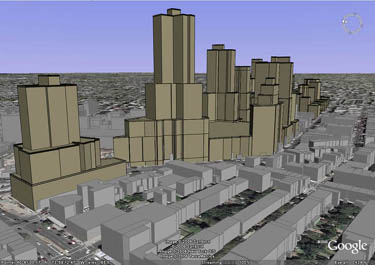
(Above right, a graphic by BrooklynSpeaks adapted from two separate renderings in the Atlantic Yards Final Environmental Impact Statement. Even with the adaptation, it's tough to get a sense of the scale from ground level.)
 The press conference organized by BrooklynSpeaks, the coalition that calls for major changes in the AY plan but does not oppose it fundamentally, was held, appropriately enough, on the row house block of Fort Greene Place in Fort Greene, in between commercial Fulton Street and the border zone of Hanson Place. Across Hanson are Forest City Ratner’s two malls, Atlantic Center and Atlantic Terminal, which already have impinged on their row house neighbors. (They were built on urban renewal land.)
Context vital
“New development can serve of all the worthy aims of the Atlantic Yards project - while also respecting its context,” said Roberta Lane, program officer and regional attorney, National Trust for Historic Preservation.
 “In the view of the National Trust for Historic Preservation, the historic brownstone neighborhoods surrounding the Atlantic Yards site are a national treasure, and preservation of their character is a national concern.”
(Graphic from the Environmental Simulation Center for the Council of Brooklyn Neighborhoods. Three buildings have since been reduced.)
“Massive in scale and incompatible in its design, Atlantic Yards should be substantially reduced and improved to address the damaging effect it will otherwise have on Brooklyn's historic and visual character,” she added.
"Brooklyn retains the largest concentration of 19th and early 20th century urban residential architecture in America,” said Andrew S. Dolkart, James Marston Fitch Professor of Historic Preservation, Columbia University. “These are cohesive neighborhoods of low-scale buildings where the skyline is generally pierced only by church steeples, school gables, or decorative iron cresting. Nearby are Fort Greene, Clinton Hill, Boerum Hill, Prospect Heights, Bedford Stuyvesant, Crown Heights. Some of these neighborhoods are historic districts, some are not yet designated, but all have extraordinary urban architecture.”
 “The proposed Atlantic Yards project is so misguided and reflects such a crisis of imagination in our government leaders on all levels and in our development community,” Dolkart added. “The project is ignoring what makes Brooklyn great – its scale, its low density, its intimacy. Not out of scale towers that bear no relationship to Brooklyn but could be built anywhere in the world.”
(At right, another graphic by BrooklynSpeaks adapted from two separate renderings in the Atlantic Yards Final Environmental Impact Statement.)
How much should it shrink?
Such quotes, of course, left open the question: how much should Atlantic Yards shrink? BrooklynSpeaks has raised the possibility of cuts by one-third or one-half, which still would involve dramatically large buildings at the northwest edge of Prospect Heights (and a corner of Downtown Brooklyn)..
“I wouldn’t answer “x number of square feet,’” Dolkart responded. “Development should occur in context with neighborhoods.” Stuart Pertz, an architect and advisor to the Municipal Art Society, a principal convenor of BrooklynSpeaks, similarly wouldn’t be pinned down. “It needs to be well-designed, and it’s not,” he said of AY.
What about an arena?
They also left open the question: how does an arena fit into such neighborhoods? (That question came to mind only later, so I didn't ask them.)
Signage fears
 The corner of Atlantic and Flatbush has the potential to be a dramatic crossroads—indeed, underground is Brooklyn’s busiest transit hub. On the other hand, it’s a block away, in one direction, from a row house street, and near many others.
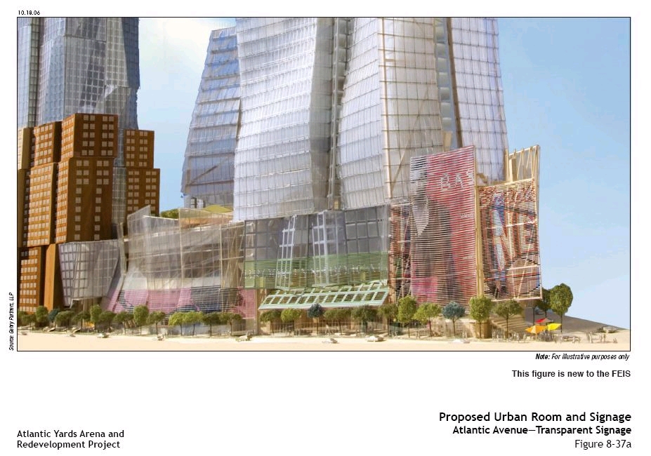
(At right, a graphic from the Draft Environmental Impact Statement, which did not fully depict the signage.)
The Empire State Development Corporation claims that the signage—both opaque and transparent—planned for the signature Urban Room and arena block wouldn’t impinge on the surrounding neighborhoods. On the other hand, the signage plan would override city regulations.
 “Our motto is ‘Change is inevitable. Ugliness is not,’” declared Kevin Fry, president of Scenic America. “The notion of 150-foot animated billboards on this development is a direct assault on the character of this community,” he added. “The developers want to create a garish, out-of-scale commercial intrusion that would not be permitted by the community otherwise. Times Square should not be exported to Brooklyn.
(Above right, a graphic from the Draft Environmental Impact Statement, which did not fully depict the signage.)
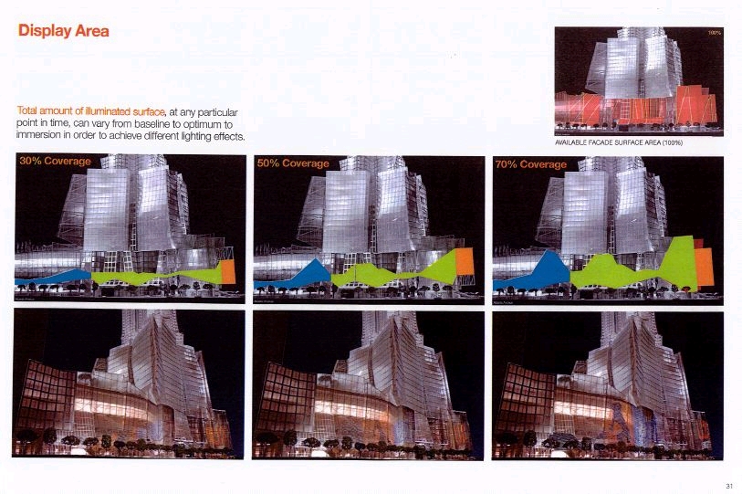
Different levels of illumination
Fry noted, “The developer claims that there will be different levels of illumination and that the brightest setting will only be used when events are going on in the arena. Of course since they have exempted themselves from the law, there will be no real way to ensure that they will resist pressure from advertisers to max out the use of the technology. The end result is pretty clear. Brooklyn’s famed brownstones will be constantly bathed in the light from 15-story-high beer ads.”
 That sounded like an exaggeration—though without better simulations, it’s hard to tell exactly what the effect would be.
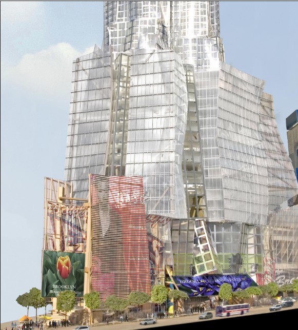
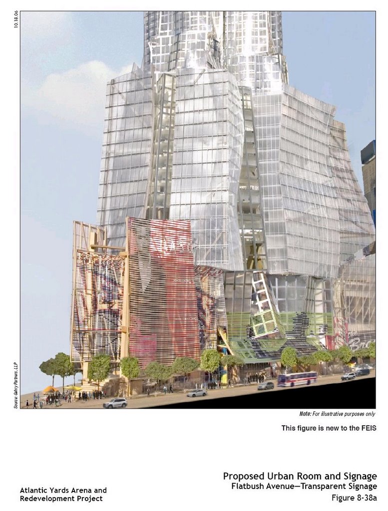
(At right, a new graphic from the Final Environmental Impact Statement. Two other such new graphics are below.)
“The outdoor advertising industry is attempting to seize the public realm for its own purposes,” Fry continued. “It’s turning our cities into nothing more than a convenient backdrop for commercial advertising…. This sign scheme should be scrapped and replaced with something in keeping with one of the great neighborhoods in the world.
 ESDC response
The Empire State Development Corporation noted that signage on the project site would be typical for local retail and commercial areas in New York City with the exception of portions of the Atlantic and Flatbush Avenue frontages…
On locations on the Atlantic and Flatbush Avenue frontages of the Arena block, specific controls would be placed that would allow for illuminated and non-illuminated opaque signs limited to the westernmost 75 feet of the Arena block (to the height of the prow extending from the Urban Room) and Building 1 (to a height of 40 feet), with additional transparent signage permitted on the Urban Room (to its full height of 80 to 150 feet), Building 1 (to a height of 60 feet), and the Arena (to a height of 40 feet).
Since the signage would be focused at the intersection of Atlantic and Flatbush Avenues, it would be visible east and west on Atlantic Avenue, north and south on Flatbush Avenue, and on a small portion of Pacific and Dean Streets south of Flatbush Avenue…
It is not expected that the proposed signage would adversely affect other historic resources in the study area. The historic resources located north of Atlantic Avenue closest to the Arena block are located north of Hanson Place, with fully developed intervening blocks containing the Atlantic Center and Atlantic Terminal Malls, with a 10-story tower rising from the north end of the three-story Atlantic Center Mall.
 These include resources No. 5 (BAM Historic District, No. 8 (Fort Greene Historic District), and No. 12 (Williamsburgh Savings Bank).
Other historic resources in the area are at too great a distance and buffered by intervening existing buildings, and some are oriented away from the signage.
So, apparently, there's a debate: exactly how much impact would such signage have?
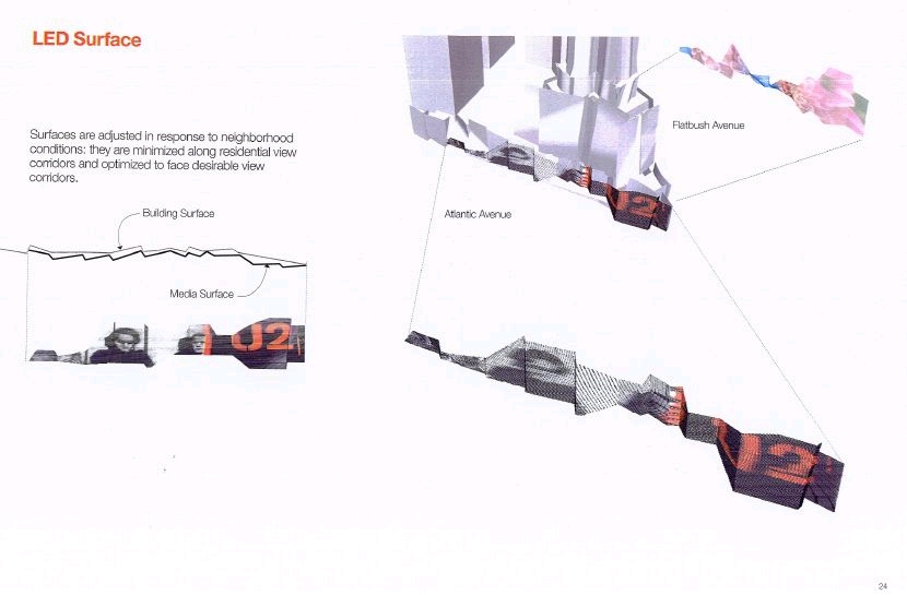
Going transparent
 ESDC observed:
The provision for “transparent signage” would allow for larger, and potentially changeable, graphic images to be located on these two frontages in a way that does not interfere with the architecture of the building or views into or out of the arena. Because of the required transparency, the larger graphics would not be particularly visible to pedestrians on the adjacent residential streets, but would have a presence from a farther distance along the Atlantic and Flatbush Avenue corridors.
The transparency issue also is contentious. At the press conference yesterday, a Municipal Art Society representative held a poster with a photograph of a very noticeable but still "transparent" sign from Midtown Manhattan.
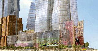
(The above graphic, and the following renderings, are from a design presentation prepared for Forest City Ratner. Note the tension between "respectful" and "immersive." Click on all to enlarge.)
New graphics
ESDC added:
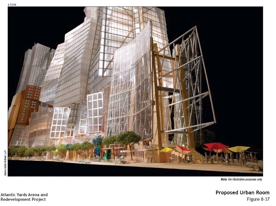
Images illustrating concepts for the signage are included in the FEIS (see Figures 8-37a through 8-38b).
 In other words, those illustrations were unavailable in the Draft Environmental Impact Statement issued in July. To recap: the top two graphics in this article are mashups by BrooklynSpeaks of the graphics in the Final Environmental Impact Statement.
Below the rendering of the project's scale are, in sequence, two graphics from the Draft Environmental Impact Statement and three new graphics from the FEIS. Below them are graphics, including the one at right, from a design presentation prepared for the developer.
Still, the ESDC did not respond to a comment from the Council of Brooklyn Neighborhoods, which stated:
Needed are comparative sections and elevations, showing signage and illumination schemes within the context of Downtown Brooklyn (BAM, etc.), as well as relevant precedents—Times Square, Madison Square Garden, e.g.
 The future of Brooklyn
The Regional Plan Association, which offered support for the plan mixed with cautions, commented:
This location at the crossroads of Flatbush and Atlantic Avenues, at the edge of Brooklyn’s commercial core and in the heart of a burgeoning cultural district, is also the perfect site for a signature project that could elevate Downtown Brooklyn as a destination and a true third Central Business District for the city...
Within reason, this “Manhattan-ization” that is proposed for Downtown Brooklyn is part of an ongoing and necessary process that will affect communities in downtowns and transit hubs across the region. However, it can and should be a process that successfully integrates large, iconic buildings with their surroundings and provides benefits that compensate for the increased congestion, noise and visual impacts that accompany these projects.
 The question remains: what exactly is that visual impact?
FCR's bigger plans
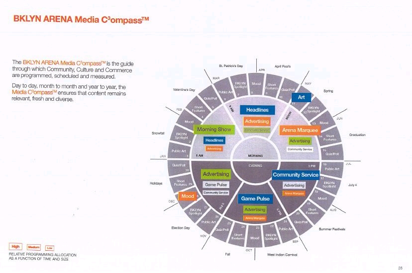
Interestingly, Forest City Ratner has considered even more ambitious plans than have been announced in the Atlantic Yards General Project Plan. Via a Freedom of Information Law request, I acquired from the Department of City Planning a document titled BKLN ARENA COMMUNITY MEDIA, credited to FCRC/GANY/NETS/AG. GANY is, I believe, Frank Gehry's New York Office, while AG refers to the Arnell Group, run by branding expert Peter Arnell.
 "This is more of a residential district. This would not be Times Square," architect Gehry told the Daily News in May. "The question was how do you create activity at game time and have it disappear."
Gehry on signage
Gehry, in an interview last April with the New York Times's Nicoloi Ouroussoff on the Charlie Rose, addressed the planned innovations in signage.
 NO: Let's be more specific--you're talking about a kind of layering--is it OK to talk about the models that I saw? We're talking about a layering around the exterior, this is around the arena in Brooklyn, it starts to peel apart, where the advertising and the facades of the buildings start to blur.
FG: So it's not there sometimes and it's there sometimes. There's a little bit of it, and there's more of it. And it can be used for community issues, as well as advertising. It has a social function, if it's played right, it can be used for art... How do you make that--everybody's getting it, whether they like it or not, it's all over us.
NO: Meaning people will have to live with this, so the question is: what can you turn it into.
 FG: If I look at what Peter Arnell and I are doing right now, they're baby steps. I really think we've got to get into the technology and see where really the root of it. Y'know, LED is little tiny things, they sit on black background--it's not pretty yet. How do you turn it into something--that's the trick. And maybe there's something other than LED.
Still the plan?
I asked DCP if the plans suggested by the document were still in force. DCP spokesperson Rachaele Raynoff responded this week, “I believe you're referring to a proposal by the developer's signage consultant for the signage on the exterior of the Arena block. DCP reviewed this document and used it to inform DCP's recommendations for the Atlantic Yards Design Guidelines for signage on the Arena block. The signage to be permitted under the Design Guidelines, as you are aware, is far more limited.”
More from the document
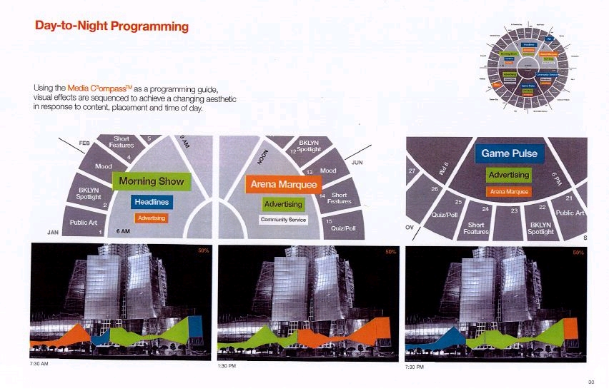
The document shows Arnell grappling with the issue of making the signage visible to people on the main streets, but not certain residential areas.


Comments
Post a Comment