 The "blighted" Atlantic Yards site (right) not only contains some historic buildings, parts are immediately adjacent to the proposed Prospect Heights Historic District. And the expected development, and its spinoffs, are causing preservationists to pressure the Landmarks Preservation Commission (LPC) to designate Prospects Heights as a historic district. (At the bottom of this article are images of the proposed project.)
A Prospect Heights Historic District (blue outline in map below) is already listed on the State and National Registers, but S/NR listing, as its known, does not protect the integrity of buildings the way an LPC designation would. Hence the new effort, led by the Municipal Art Society (MAS), the Prospect Heights Neighborhood Development Council, and others.
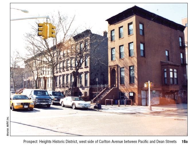
 The map prepared by MAS suggests a much larger outline, in red. Note that the northern finger of the existing and proposed historic district, on the west side of Carlton Avenue between Dean and Pacific streets, would be directly opposite the Atlantic Yards project at its north and east edges.
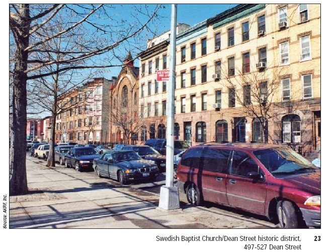
On the south side of Dean Street, six buildings east of Sixth Avenue, would be the (S/NR-eligible) Swedish Baptist Church/Dean Street Historic District, consisting of townhouses and churches; its western border would be immediately adjacent to Atlantic Yards.
Given the value of historic buildings, and the growth in Brooklyn, it raises a question about whether the proposed site would remain substantially unchanged without the Atlantic Yards plan. The ESDC said it would, despite much skepticism from community groups.
New pressures
According to a MAS article:
Prospect Heights is an area rich with the historic architecture that helps shape Brooklyn’s special identity. The neighborhood contains blocks lined with beautiful Italianate and neo-Grec rowhouses, interspersed with churches, small commercial buildings and multi-family structures. Originally a quiet farm area crossed by the historic Flatbush Turnpike Road, Prospect Heights became a residential neighborhood in the second half of the nineteenth century after the completion of nearby Prospect Park. The area is widely recognized as an important historic neighborhood, and indeed, part of the neighborhood is listed on the National Register.
With the Atlantic Yards proposal moving ahead, it is crucial that Prospect Heights gain protection through historic district designation before development pressures resulting from the project permanently alter the its intact historic character.
The proposal should be considered by the LPC within the next year.
What the FEIS says
Chapter 7 (Cultural) of the Final Environmental Impact Statement (FEIS) for Atlantic Yards notes that LPC has determined that the NYCL-eligible historic district is a well preserved district of rowhouses and religious structures dating from the 1870s through 1890s.
 The document from the Empire State Development Corporation (ESDC) also cites the Swedish Baptist Church/Dean Street Historic District (right), noting that Overall, the rowhouse clusters and the former Swedish Baptist Church that make up this block represent a relatively intact reflection of the period from ca. 1870-1910 in which Prospect Heights was developed.
How much impact?
The FEIS first acknowledges that parts of the Prospect Heights Historic District are within 80 or 90 feet from proposed Atlantic Yards towers, as are four buildings in the Swedish Baptist Church/Dean Street S/NR-eligible historic district, and the Pacific Branch of the Brooklyn Public Library on Fourth Avenue at Pacific Street.
The FEIS warns: Demolition of all structures on the site, followed by site preparation, including the use of heavy machinery, could potentially result in inadvertent damage to the historic resources described above if adequate precautions are not taken... Therefore, to avoid inadvertent demolition- and/or construction-related damage to these resources from ground-borne construction-period vibrations, falling debris, collapse, etc., these 15 buildings would be included in a CPP [Construction Protection Plan] for historic structures...
Contextual impacts?
 The interesting question comes when the FEIS analyzes the contextual impact of the development, which would include an arena and 16 towrs. While four buildings on the north side of Dean Street between Carlton and Vanderbilt Avenues would range in height from approximately 180 feet to 280 feet, at the sidewalk, the streetwalls woudl be between 60 feet and 105 feet in height, so the scale "while larger than that of the buildings in the historic district, would be more suited to the narrow street." Also, the bases of the buildings on Carlton and the portions of the buildings on the north side of Dean east of Carlton "would have a traditional massing and be clad in masonry."
(At right, the "finger" on Carlton Avenue between Dean and Pacific streets)
Still, the FEIS acknowledges:
It is expected that Buildings 11-14 on Block 1129 and the proposed open space on Block 1120 would alter the built form of areas immediately north and east of the S/NR-listed and NYCLeligible Prospect Heights Historic District. The buildings would be taller and have larger footprints than those located in the historic district. However, the proposed development would not isolate the historic district from its setting or streetscape the buildings would continue to be separated from the surrounding urban context by Carlton Avenue and Dean Street. The width of Carlton Avenue especially (at approximately 80 feet), would allow for a visual separation between the historic row of buildings on the west side of Carlton Avenue and the proposed new development.
Enclaves not affected?
It all depends on how you look at context:
As described above, OPRHP [the state agency] has determined that the S/NR-listed Prospect Heights Historic District is significant since it constitutes an intact and cohesive enclave of predominantly late-19th-century buildings. LPC has determined that the NYCL-eligible historic district is a well preserved district of rowhouses and religious structures dating from the 1870s through 1890s. The proposed project would not affect these characteristics, but would change the larger setting in which the district is located. Since the S/NR-listed and NYCL-eligible district boundaries were drawn to eliminate areas surrounding the district that did not contribute to the district’s cohesive architectural character, altering these non-contributing areas would not be expected to result in significant adverse impacts to the context of the S/NR-listed and NYCL-eligible Prospect Heights Historic District.
The diciest juxtaposition may be at the northeast corner of Dean Street and Sixth Avenue:
The proposed 272-foot-tall Building 15 on Block 1128 would be adjacent to the Swedish Baptist Church/Dean Street historic district (Resource No. 23 of Figure 7-2). The approximately 25-story building would be located approximately 15 feet from the westernmost building in the historic district, a four-story brick rowhouse at 497 Dean Street dating to the late 19th century.
 The proposed building would replace 5 two- to three-and-a-half-story 19th-century residential buildings (right) that have been substantially altered with new sidings, windows, and ground-floor alterations. The proposed height and the modern design of the building would contrast with the historic character of the 19th-century rowhouses and the former Swedish Baptist Church that make up the historic district. However, the north side of Dean Street is broken up in two locations, with open areas and driveways relating to a condominium building located at 700 Pacific Street, and does not present a consistent streetwall. In this context, the small historic district exists as an architecturally distinguished enclave and fragment of a once larger intact 19th-century streetscape. The proposed new building would be located at the west end of the block and, therefore, would not break up the district. Although the brick rowhouses and Swedish Baptist Church were built during the same time period as the five buildings that would be demolished on the site of Building 15, the historic relationship between the five buildings on the site of Building 15 and those located within the historic district has been altered. Changes to the buildings on the site of Building 15 have resulted in a loss of these buildings’ integrity, with the exception of their scale and general configuration.
Note my comments on the state's arbitrary finding of blight.
However, because Building 15 "would be faced in masonry," according to the FEIS, it would "be in keeping with the cladding of the church and rowhouses" next to it. Scroll to the bottom for a visual.
Overview
The FEIS concludes that, while "the new buildings would contrast with the footprints, heights, and classical designs of the rowhouses" in nearby and more distant historic districts, they "would continue to be enclaves of cohesive historic buildings that exist in larger altered contexts." The FEIS asserts that the new residential development "would complement the primarily residential uses in the historic districts and remove what has historically been a physical and visual barrier in the urban fabric"--which has, of course, been challenged by those who contend that the project would create a barrier.
 (See BrooklynSpeaks and the UNITY plan.)
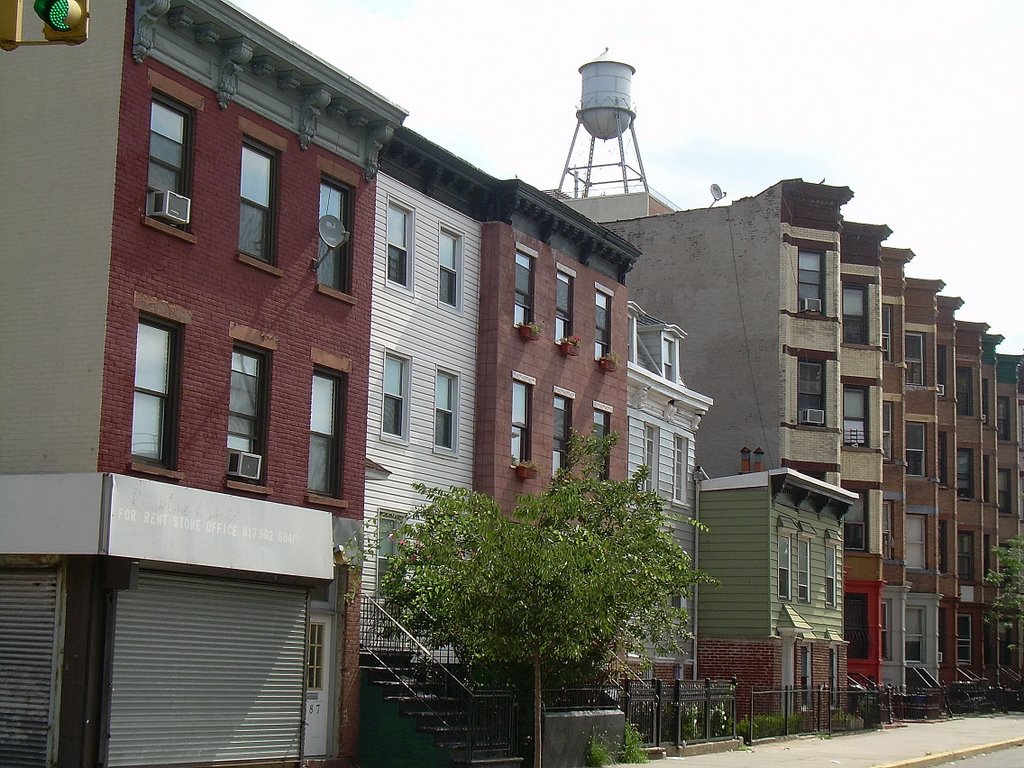
Of course, one question is what happens when individual buildings are outside the district. That large outline between Dean and Pacific streets west of Vanderbilt Avenue is the Ward Bakery (right), scheduled to be demolished by Forest City Ratner and the scene of a planned demonstration on Sunday. It was not listed by the LPC (see Brooklyn Paper), but it is S/NR-eligible, and its loss would be a significant adverse impact, according to the FEIS, mitigated by some sort of documentation.
 However, it's unclear why the loss of the Spalding Building (right), a former factory rehabilitated into housing, would not be considered a significant adverse impact. It also reflects the area's industrial heritage, and, while the original signage is gone, it's already been renovated. However, the politics of protest would be more challenging; the Spalding Building is scheduled to be demolished for Phase 1 of the project, and BrooklynSpeaks is focusing on Phase 2 and demolition for parking.
What it might look like
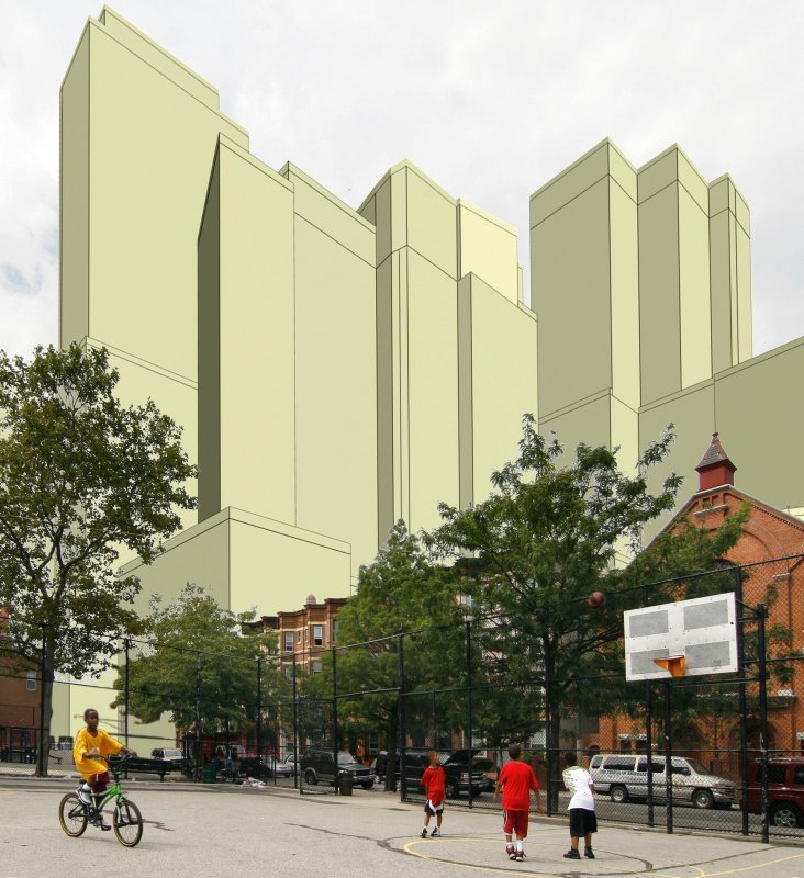 Shortly before the Atlantic Yards public hearing 8/23/06, after Brooklyn photographer Jonathan Barkey produced photosimulations (such as at the Dean Street playground, right), trying to show the public images of the Atlantic Yards project that were not available in the ESDC's Draft Environmental Impact Statement, issued 7/18/06.
Those graphics apparently made an impression. The FEIS, issued 11/15/06 (then updated and reissued 11/27/06), incorporated some projected views of the Atlantic Yards project unavailable in the earlier version.
A different scale
 The result (right) is a more detailed sense of the future buildings, courtesy of Gehry Partners. The scale is relatively smaller, as well.
Can we trust that depiction? Gehry's images should be more accurate, given that he has access to more precise data regarding the project. Then again, there's reason to doubt the accuracy of Gehry's images--remember the Williamsburgh Savings Bank dwarfing Miss Brooklyn? (At that point Miss Brooklyn was 108 feet taller and three times bulkier.)
And we might wonder how Gehry found a photo with the exact same configuration of children. Indeed, Gehry apparently borrowed Barkey's photo and claimed credit, rather than either crediting Barkey or simply providing no attribution.
Comments
Post a Comment