Atlantic Yards paradox, Part 2: the footprint area doesn't count for "neighborhood character," but it sure did for blight
Yesterday I wrote Atlantic Yards paradox, Part 1, observing that Empire State Development's dismissal of a multi-developer alternative to build Atlantic Yards was indeed plausible, but only because the state agency changed the rules, extending Forest City Ratner's deadline from ten to 25 years but leaving a complex series of transactions in place that would be extremely difficult to unwind.
Another paradox shines through the court-ordered Draft Supplemental Environmental Impact Statement (SEIS) issued last Friday, which evaluates the community impacts of a potential 25-year buildout for Phase 2 (11 towers east of Sixth Avenue) and concludes there are relatively few, and most of them can be mitigated.
As in the Final EIS issued in 2006, the Draft SEIS concludes that the blocks around the Atlantic Yards site would experience "significant adverse localized neighborhood character impacts." Now they could extend 18 years rather than six years.
But such "localized impacts would not result in significant adverse neighborhood character impacts in the Prospect Heights neighborhood" and though the delay "would defer temporarily the benefits of Phase II, the benefits would nevertheless improve the character of the neighborhood when construction is completed."
So there's a problem, it will last longer than expected/analyzed, it will all be resolved, and it doesn't matter for the purpose of environmental analysis, because its a "localized" area, but not a neighborhood.
 Surely it's a stretch for the state to say that an additional 12 years is merely "consistent" with previous findings. (I've called a similar claim "the meaninglessness of time.")
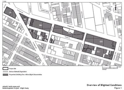
But the larger paradox is this: when it came time to study blight, the state agency limited itself to the odd map Forest City Ratner chose and deliberately ignored its plan to conduct a market study of property in the surrounding area, which was clearly gentrifying.
In other words, when it came to blight, the larger neighborhood context--which could have demolished the study's conclusions--didn't matter.
When it comes to neighborhood impacts, the larger neighborhood context--in which the impacts can be mostly dismissed--holds sway.
That's called having it both ways.
The blight study
ESD (aka Empire State Development Corporation) asserted, attempting a straight face, "The blighted conditions appear to be limited in large part to the project site itself."
However, as I wrote, that map was highly arbitrary, and clearly expedient.
For example, the site for Building 15, the unbuilt site in the graphic at right, was chosen likely because it could serve as temporary surface parking and staging during the construction of the arena block, Phase 1.
The map included un-blighted parcels but deliberately omitted a vacant lot, which was blighted under the state's definition.
However, because Forest City chose to build only the arena, and decouple the four towers, the site east of Sixth Avenue was not needed. Part of it now serves as a parking lot of TV trucks and other vehicles.
During construction: neighborhood character
 According to the Chapter 3L of the Draft SEIS, Construction Land Use and Neighborhood Character:
 (all emphases added)
During operation: neighborhood character
The chapter on Operational Neighborhood Character comes to similar conclusions:
The document states:
Note that "neighborhood character" is not a colloquial phrase but a section in City Environmental Quality Review (CEQR), the technical manual for which is also used by the state. According to the chapter on Neighborhood Character, it states:
Interestingly, the manual does note:
Neighborhood vs. sub-neighborhood
The manual notes:
Prospect Heights was not "shot to hell." Nor was the project footprint. But the blight designation was very helpful.
Well, as Brooklyn Legal Services' Marty Needleman told City Council yesterday during a hearing about the plan for the Domino sugar refinery site, "The law's what you can get away with."
Another paradox shines through the court-ordered Draft Supplemental Environmental Impact Statement (SEIS) issued last Friday, which evaluates the community impacts of a potential 25-year buildout for Phase 2 (11 towers east of Sixth Avenue) and concludes there are relatively few, and most of them can be mitigated.
As in the Final EIS issued in 2006, the Draft SEIS concludes that the blocks around the Atlantic Yards site would experience "significant adverse localized neighborhood character impacts." Now they could extend 18 years rather than six years.
But such "localized impacts would not result in significant adverse neighborhood character impacts in the Prospect Heights neighborhood" and though the delay "would defer temporarily the benefits of Phase II, the benefits would nevertheless improve the character of the neighborhood when construction is completed."
So there's a problem, it will last longer than expected/analyzed, it will all be resolved, and it doesn't matter for the purpose of environmental analysis, because its a "localized" area, but not a neighborhood.

But the larger paradox is this: when it came time to study blight, the state agency limited itself to the odd map Forest City Ratner chose and deliberately ignored its plan to conduct a market study of property in the surrounding area, which was clearly gentrifying.
In other words, when it came to blight, the larger neighborhood context--which could have demolished the study's conclusions--didn't matter.
When it comes to neighborhood impacts, the larger neighborhood context--in which the impacts can be mostly dismissed--holds sway.
That's called having it both ways.
The blight study
ESD (aka Empire State Development Corporation) asserted, attempting a straight face, "The blighted conditions appear to be limited in large part to the project site itself."
However, as I wrote, that map was highly arbitrary, and clearly expedient.

For example, the site for Building 15, the unbuilt site in the graphic at right, was chosen likely because it could serve as temporary surface parking and staging during the construction of the arena block, Phase 1.
The map included un-blighted parcels but deliberately omitted a vacant lot, which was blighted under the state's definition.
However, because Forest City chose to build only the arena, and decouple the four towers, the site east of Sixth Avenue was not needed. Part of it now serves as a parking lot of TV trucks and other vehicles.
During construction: neighborhood character
According to the Chapter 3L of the Draft SEIS, Construction Land Use and Neighborhood Character:Construction of Phase II of the Project under the Extended Build-Out Scenario is not expected to result in significant adverse neighborhood character impacts in neighborhoods surrounding the Phase II project site; however, increased traffic, noise, and views of construction activity would result in significant adverse localized neighborhood character impacts in the immediate vicinity of the Phase II project site. During construction, the project site and the immediately surrounding area would be subject to added traffic from construction trucks and worker vehicles and partial sidewalk and lane closures; in particular, construction traffic and noise would change the quiet character of Dean Street, Pacific Street and Carlton Avenue in the immediate vicinity of the project site. In addition, staging activities, temporary sidewalks, construction fencing, and construction equipment and building superstructure would be visible to pedestrians in the immediate vicinity of the Phase II project site...
These impacts would occur for a longer period of time than what was contemplated in the 2006 FEIS, as the duration of construction activities for Phase II under the Extended Build-Out Scenario would be 18 years, compared with six years in the 2006 FEIS. The impacts would be localized, confined largely to Dean Street, Pacific Street, and Carlton Avenue, and no immediate area would experience the effects of the Project’s construction activities for the full project construction duration. Measures to control noise, vibration, and dust on construction sites, including the erection of construction fencing, would reduce views of construction sites and buffer noise emitted from construction activities, and sound barriers would be used to reduce noise from particularly noisy activities where practicable. However, significant traffic and noise impacts and the effects of views of the construction sites would affect neighborhood character in the areas immediately adjacent to the Phase II project site for a prolonged period under the Extended Build-Out Scenario.
Consistent with the 2006 FEIS, this SEIS finds that construction of Phase II of the Project would not result in significant adverse neighborhood character impacts beyond the significant adverse localized impacts in the immediate vicinity of the project site.
(all emphases added)During operation: neighborhood character
The chapter on Operational Neighborhood Character comes to similar conclusions:
Consistent with the 2006 FEIS and 2009 Technical Memorandum, this SEIS analysis finds that while Phase II of the Project would result in localized adverse neighborhood character impacts along Dean Street due to increased activity and significant adverse traffic and pedestrian condition impacts, and along Bergen Street due to significant adverse traffic impacts, these impacts would be highly localized and would not result in significant adverse neighborhood character impacts. While a delay in construction of Phase II of the Project under the Extended Build-Out Scenario would defer temporarily the benefits of Phase II, the benefits would nevertheless improve the character of the neighborhood when construction is completed. Overall, Phase II of the Project under the Extended Build-Out Scenario would have a beneficial effect on neighborhood character, creating a vibrant mixed use area, improving the streetscape in and around the project site and knitting together the neighborhoods north and south of the rail yard.Summarizing the FEIS:
The 2006 FEIS indicated that the Project would result in localized adverse neighborhood character impacts in certain areas closest to the project site. In general, areas of localized impact identified in the 2006 FEIS related to the Phase I development, which is not the subject of this SEIS. However, the 2006 FEIS did identify localized adverse neighborhood character impacts on Dean Street along the southern border of the project site (including the eastern portion, adjacent to the Phase II project site), a street that would change from a nondescript, but quiet, mixed-use (i.e., industrial, commercial and residential) street to an active street with a mix of uses. However, the 2006 FEIS concluded that Dean Street does not possess the attributes and character of the stable residential districts more readily identifiable within the Prospect Heights neighborhood to the south. The core of the Prospect Heights neighborhood is preserved in an historic district (the Prospect Heights Historic District). Residential uses in this district, and most of the neighborhood south of St. Mark’s Avenue and west of Washington Avenue, are found on quiet tree-lined streets characterized by uninterrupted rows of attached two- to four-story rowhouses faced in brick and brownstone that are typically set back from the street and allow for a small front garden. Changes in neighborhood character along Dean Street would not affect the historic residential areas of Prospect Heights.Comparing Draft SEIS and FEIS
The 2006 FEIS concluded that the changes to the overall character of Dean Street would not be significantly adverse, and that overall the Project would not result in significant adverse neighborhood character impacts. To the contrary, the 2006 FEIS concluded that Phase II of the Project would further City policies and redevelopment objectives associated with the Atlantic Terminal Urban Renewal Area (ATURA), transforming the project site into a vibrant mixed-use area and knitting together the surrounding neighborhoods which have long been separated by the physical and visual barrier formed by the open rail yard.
The document states:
Consistent with previous environmental analyses, this SEIS concludes that operation of Phase II of the Project upon completion under the Extended Build-Out Scenario would not result in significant adverse neighborhood character impacts. Traffic impacts would vary somewhat from those identified in the 2006 FEIS due to a number of factors such as changes in transportation planning factors, travel characteristics of Arena patrons, and updated No Build projects and baseline traffic count. However, the general location and magnitude of impacts identified in the SEIS and 2006 FEIS are comparable as they relate to the character of neighborhoods surrounding the project site. Unmitigated traffic impacts associated with Phase II development under the Extended Build-Out Scenario, coupled with increases in pedestrian activity, would result in localized neighborhood character impacts along Dean Street and Bergen Street, the one-way east-west couplet on the southern boundary of the project site, but these localized impacts would not result in significant adverse neighborhood character impacts in the Prospect Heights neighborhood.
On the contrary, significant neighborhood character benefits would result upon completion of Phase II of the Project under the Extended Build-Out Scenario, in that it would transform the site into a vibrant mixed use neighborhood with eight acres of open space, improve the streetscape and connect the neighborhoods to the north and south of the rail yard. While a delay in construction would defer these benefits temporarily, the benefits would nevertheless improve the character of the neighborhood when construction is completed. These SEIS findings are consistent with those presented in the 2006 FEIS for neighborhood character.Looking at CEQR
Note that "neighborhood character" is not a colloquial phrase but a section in City Environmental Quality Review (CEQR), the technical manual for which is also used by the state. According to the chapter on Neighborhood Character, it states:
In a neighborhood character assessment under CEQR, one considers how elements of the environment combine to create the context and feeling of a neighborhood and how a project may affect that context and feeling. Thus, to determine a project's effects on neighborhood character, the elements that contribute to a neighborhood’s context and feeling are considered together.It states:
...Neighborhood character impacts are rare. Only under unusual circumstances would a combination of moderate effects to the neighborhood result in an impact to neighborhood character, in the absence of an impact in any of the relevant technical areas.
Moreover, a significant impact identified in one of the technical areas that contribute to a neighborhood’s character is not automatically equivalent to a significant impact on neighborhood character. Rather, it serves as an indication that neighborhood character should be examined. The examination focuses on whether a defining feature of the neighborhood's character may be significantly affected. For example, a significant traffic impact may occur if a project adds ve hicles to an intersection, increasing the delay to unacceptable levels. This significant impact would not constitute an impact on neighborhood character, however, if a neighborhood’s traffic conditions are not considered one of its defining features (i.e., if the traffic conditions are comparable to those of many other neighborhoods and areas in the City).
To determine whether a Neighborhood Character assessment is appropriate, answer the following question:What's the study area?
Would the project have the potential to result in any significant adverse impacts in the following areas?If “Yes,” a preliminary assessment of neighborhood character may be appropriate. For guidance on conducting a preliminary neighborhood character assessment, proceed to Section 310, below. If the answer is “No,” a preliminary assessment of neighborhood character probably is not required. However, depending on the project, a combination of moderate changes in several of these technical areas may potentially have a significant effect on neighborhood character. See Section 220, below, for further information.
- Land Use, Zoning, and Public Policy;
- Socioeconomic Conditions;
- Open Space;
- Historic and Cultural Resources;
- Urban Design and Visual Resources;
- Shadows;
- Transportation; or
- Noise.
Interestingly, the manual does note:
Smaller study areas may be appropriate if the neighborhood that may be affected is itself smaller than the typical study area. An example may be a mid-rise (15- to 20-story) building proposed for midblock in a residential part of the Upper West Side of Manhattan and the midblock portion of the block has a strongly defined low-rise (four- to five-story) residential character that is very different from the ends of the block, where mid-rise buildings with ground floor retail front wide avenues. The proposed building may not affect the character of the ends of the block, but may affect the mid-block portion. Therefore, it may be appropriate for the study area to focus on the midblocks. Considering a study area that is too large would dilute the intensity of the effects.I'll note that critics who consider environmental review too burdensome would like to see the "neighborhood character" concept eliminated.
For generic actions that would affect relatively small areas, the affected areas would serve as the study area. When large areas would be affected, the analysis considers neighborhoods typical of those that would be affected.
Neighborhood vs. sub-neighborhood
The manual notes:
In general, the more uniform and consistent the existing neighborhood context, the more sensitive it is to change. A neighborhood that has a more varied context is typically able to tolerate greater changes without experiencing significant impacts.There's a logic to that. But that same logic goes to the paradox I identified: were the blighted conditions truly those that might mean, as an urban planner would put it, "the fabric of a community is shot to hell"?
Prospect Heights was not "shot to hell." Nor was the project footprint. But the blight designation was very helpful.
Well, as Brooklyn Legal Services' Marty Needleman told City Council yesterday during a hearing about the plan for the Domino sugar refinery site, "The law's what you can get away with."
Comments
Post a Comment