Exhibit: The City We Imagined/The City We Made: New New York 2001-2010 (including, of course, Atlantic Yards)
An exhibition at The Architectural League, The City We Imagined/The City We Made: New New York 2001-2010, concerns architecture, planning, and development in New York since 2001.
It's well worth watching and, yes, Atlantic Yards is a component of the story. Still--and this is some useful perspective for those of us focused on AY--so much in New York has changed that it's understandable that those elsewhere in the city may find it hard to pay attention to all.
The free exhibition is on view at 250 Hudson Street (entrance on Dominick Street) until June 26 and should move to a summertime venue beginning on the July 4th weekend. It's open Wednesday-Sunday, Noon-7 pm.

Summary description
From the blurb:
Just think: multiple rezonings, landmark designations, new buildings, multiple megaprojects, five boroughs. The High Line has gotten much positive publicity, and it's an admirable project, but I find the reconstructed Coney Island subway terminus, which opened in May 2004, is as impressive a public project as any.
On the back of the main exhibit: some 1000 photographs of the city, taken by hundreds of contributors. (Here's the Architect's Newspaper on that process.)
Outside perspective
Writes Justin Davidson in New York Magazine:
The timeline for Atlantic Yards logs multiple episodes but, curiously enough, has several mistakes, including the claim that Forest City Ratner in "Summer 2002" announced plans "to build on a 22-acre site owned by MTA at intersection of Atlantic and Flatbush Avenues that includes Vanderbilt Railyards" and that in January 2003, "MTA announces it will sell Vanderbilt Railyards to Forest City Ratner."
Actually, secondhand reports of the project emerged in the summer of 2003 and the project wasn't officially unveiled until 12/10/03.
Nor did the MTA select Forest City Ratner "as developer of the Atlantic Yards site," because the MTA controlled only the Vanderbilt Yard. Had the MTA controlled all the land, there wouldn't have been an eminent domain battle.
(Update: Curator Gregory Wessner promises corrections.)
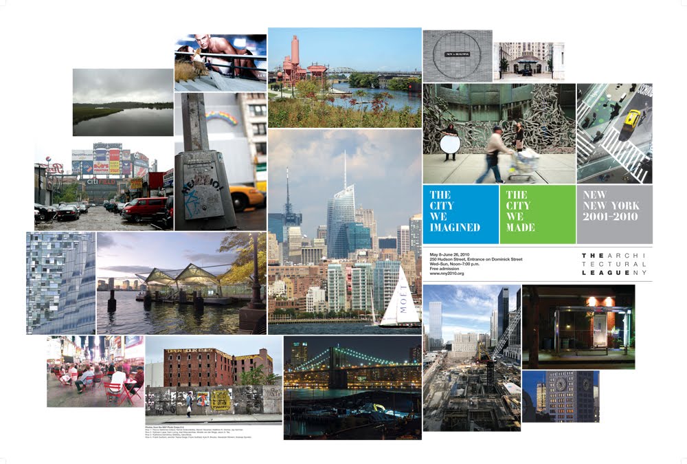
The brochure
 From the blurb
The exhibition includes:
The video
Archipelago (11:37 in length) is an original Urban Omnibus video production that explores a day in the life of five New York neighborhoods: Hunts Point, Jamaica, Mariner’s Harbor, Downtown Brooklyn, and Chelsea.
From the promo:
It's well worth watching and, yes, Atlantic Yards is a component of the story. Still--and this is some useful perspective for those of us focused on AY--so much in New York has changed that it's understandable that those elsewhere in the city may find it hard to pay attention to all.
The free exhibition is on view at 250 Hudson Street (entrance on Dominick Street) until June 26 and should move to a summertime venue beginning on the July 4th weekend. It's open Wednesday-Sunday, Noon-7 pm.

Summary description
From the blurb:
The City We Imagined/The City We Made: New New York 2001-2010 is the sixth in an ongoing series of Architectural League exhibitions about contemporary architecture in New York City. This installment takes as its subject the design, planning, and building of New York in the first decade of the twenty-first century. Beginning in 2001, an array of powerful forces converged to dramatically transform large portions of the city. The events of September 11, the policies and priorities of the Bloomberg Administration, the volatile ups and downs of the global and local economies, advances in material and construction technologies, and a new interest among the public in leading edge architecture all combined to reshape New York in ways that we may not fully grasp for decades to come.The main part of the exhibit consists of three linear horizontal rows stretching over multiple panels, accounting for development over the decade. One row involves public projects, another private ones, and another public-private ones.
The City We Imagined/The City We Made documents this recent chapter in the city’s history, providing an overview of the most notable projects and proposals, plans and initiatives, so that New Yorkers can begin to shape an overall understanding of the decade and consider what the cumulative impact of this era of planning and building might be.
Just think: multiple rezonings, landmark designations, new buildings, multiple megaprojects, five boroughs. The High Line has gotten much positive publicity, and it's an admirable project, but I find the reconstructed Coney Island subway terminus, which opened in May 2004, is as impressive a public project as any.
On the back of the main exhibit: some 1000 photographs of the city, taken by hundreds of contributors. (Here's the Architect's Newspaper on that process.)
Outside perspective
Writes Justin Davidson in New York Magazine:
What emerges from the exhibit is how, even as New York transformed, it hardly changed at all, especially if you compare the aughts with other decades in which the city was remade. In 1920, the elevated subway that sliced through Sunnyside and Woodside ran above barren mudflats; a decade later, those blocks were a dense grid of buildings. It took only a handful of years in the fifties to raze vast swaths of the Lower East Side and erect a mountain range of housing projects. The last decade has not seen mass erasures on that scale.Writes Julie Iovine in the Wall Street Journal:
About AYThe data are printed on 8-by-11 sheets of color-coded paper (zoning ordinances, for instance, on orange), so you can see at a glance that there was only one rezoning in 2001—but almost two dozen in 2005. Relive Forest City Ratner's battle with assorted Brooklynites over the proposed $4.9 billion Atlantic Yards development on panels for 2003 and for 2005 through 2010, as the dispute approaches blood sport. Park projects (on pink) come in sporadic waves, and it's hard to miss the oppressive reality that the scores of ambitiously designed condominiums conceived in 2007 are arriving with a thud in 2010.
The timeline for Atlantic Yards logs multiple episodes but, curiously enough, has several mistakes, including the claim that Forest City Ratner in "Summer 2002" announced plans "to build on a 22-acre site owned by MTA at intersection of Atlantic and Flatbush Avenues that includes Vanderbilt Railyards" and that in January 2003, "MTA announces it will sell Vanderbilt Railyards to Forest City Ratner."
Actually, secondhand reports of the project emerged in the summer of 2003 and the project wasn't officially unveiled until 12/10/03.
Nor did the MTA select Forest City Ratner "as developer of the Atlantic Yards site," because the MTA controlled only the Vanderbilt Yard. Had the MTA controlled all the land, there wouldn't have been an eminent domain battle.
(Update: Curator Gregory Wessner promises corrections.)
The brochure
 From the blurb
The exhibition includes:
•The City We Imagined: A timeline of the major architecture and planning events of the past ten yearsThere are also video interviews with leading New Yorkers, which are not yet available online. (They're tough to pay attention to at the exhibit.)
•The City We Made: 1000 photographs taken by the New New York Photography Corps, a volunteer group of nearly one hundred architects and design professionals who spent more six months beginning in October 2009 documenting the city
•Archipelago: A video production of Urban Omnibus, exploring a day in the life of five New York neighborhoods: Hunts Point, Jamaica, Mariner’s Harbor, Downtown Brooklyn, and Chelsea. Click here to watch.
The video
Archipelago (11:37 in length) is an original Urban Omnibus video production that explores a day in the life of five New York neighborhoods: Hunts Point, Jamaica, Mariner’s Harbor, Downtown Brooklyn, and Chelsea.
From the promo:
Archipelago seeks to explore how the physical environment of New York is used and experienced in one neighborhood in each of the five boroughs. Each of these communities has undergone changes both visible and invisible in the past ten years, wrought by development in some cases and disinvestment in others. Each defies preconceptions while attesting to the baffling complexity of the city’s systems, from the world’s largest food distribution facility to the AirTrain JFK, from the luxury high-rises along the High Line to the mobile homes beneath Goethals Bridge. And each is worthy of a visit.The Downtown Brooklyn segment, which begins at about 7:35, goes by in a 90-second blink. Newer towers like the Forte, 80 DeKalb, Toren, Metrotech are captured amid the older streetscape of places like Borough Hall, Cadman Plaza, and the Fulton Mall. The camera doesn't come close to the intersection of Atlantic and Flatbush avenues.
Comments
Post a Comment