 The text from state Supreme Court Joan Madden's decision January 11 (right), as posted by Develop Don't Destroy Brooklyn (DDDB), pointed me to a curious locution used by the Empire State Development Corporation (ESDC): "most of the residents in the area continue to live among conditions that are unsanitary and unsafe."
(Emphasis added)
That deserves a closer look, since I and many others apparently ignored the linguistic switch from "in" to "among."
The primary definition of "among," according to the dictionary, means In the midst of; surrounded by. But the blight conditions cited by the ESDC in the passage quoted do not surround any residences.
Indeed, DDDB, in its response to the ESDC's Blight Study commented:
And there is no evidence anywhere in the entire Blight Study that residents of the study area live among unsanitary and unsafe conditions. That assertion is laughable, had the compilers of this Blight Study bothered to talk with residents of the footprint site they would have found not one who would say they live in unsanitary and unsafe conditions.
(Emphases added)
I asked attorney George Locker, who represents rent-stabilized tenants in two buildings in the Atlantic Yards footprint, about the conditions of those apartments.
 "The general condition is satisfactory," he responded. "There's certainly nothing unsanitary. The most important thing is they live in structurally sound buildings." Their biggest complaint? "The environment is inhospitable," he said, citing construction noise. "That's really affecting them." (The tenants are involved in two lawsuits challenging aspects of the project.)
What the ESDC said
Let's look at Section B of the Blight Study. The ESDC wrote:
Comparing conditions in Photographs F and G with conditions depicted in Photographs H and I further illustrates the progress in removing blight from ATURA north of Atlantic Avenue compared to continued unsanitary conditions and underutilization of the properties south of Atlantic Avenue immediately adjacent to ATURA. Photographs F and G depict streets and buildings that are typical to the revitalized areas of ATURA north of Atlantic Avenue.
 Photograph F shows some of the recently completed multi-family housing administered by the New York City Housing Partnership (left) and the eastern façade of the Atlantic Center mall (right). The bridge that crosses the rail yard between Blocks 1119 and 1120 is visible in the picture’s background. Photograph G shows more recently constructed multi-family housing at the corner of Fulton Street and Carlton Avenue, one block north of Atlantic Avenue.
Note that, in Photograph F, the eastern façade of the Atlantic Center mall, an anti-urban blank wall, is hardly the sign of a thriving neighborhood. Planner (and DDDB advisory board member) Ron Shiffman has described the mall as the "only pre-existing blighting influence" in the area around the footprint. And as I observed, it's built to less than 60% of the allowable development rights, an indication of blight, according to the ESDC's standard as applied to the AY footprint.
(Click on the map at bottom to see the block numbers.)
Below Atlantic Avenue
 The Blight Study continued:
In contrast, as illustrated by Photographs H and I, the blocks south of Atlantic Avenue host a combination of vacant, underutilized, and physically deteriorating structures and vacant lots, and are lined with cracked and crumbling sidewalks that are overgrown with weeds and strewn with trash. Photograph H shows the fenced rail yard and deteriorated sidewalk to the right (Block 1121, lot 1) and an old warehouse building (Block 1129, lot 25) to the left.
Note that the Blight Study does not deal with who might be responsible for the deteriorated sidewalk and the weeds. (More on that below.) Certainly these are not the conditions in (or even among) which residents live, since there's no housing on the north side of Pacific Street.
As for the "old warehouse building," that's the Ward Bakery, which developer Shaya Boymelgreen (who developed the nearby Newswalk) was said to have considered for a hotel, but instead made a quick killing by selling it to Forest City Ratner for more than double what he paid.
 The Blight Study continued:
Further west along that same block, Photograph I shows the fenced rail yard to the right and a primarily vacant warehouse building (Block 1129, lot 13) to the left. In the background of the picture, beyond lot 13, is a market rate condominium building (Newswalk), which is not part of the proposed project site. Other market rate condominium buildings in the immediate vicinity include: 618 Dean Street on the south side of Dean Street between Carlton and Vanderbilt Avenues (not part of the project site) and 636 Pacific Street and 24 6th Avenue (part of the proposed project site).
That primarily vacant warehouse building, however, is in excellent shape, and owner Henry Weinstein has said he wanted to convert it into housing.
Market-rate condos
 The Blight Study continued:
The proximity of these market-rate condo buildings to the blighted properties profiled in this study indicates that, although some isolated redevelopment has occurred on blocks just south of the ATURA boundary, most of the residents in this area continue to live among conditions that are unsanitary and unsafe.
(Emphasis added)
The value of perspective
The Blight Study continued:
Photograph J, taken from the north side of Atlantic Avenue looking south over the rail yard on Block 1119, again demonstrates the contrast between redevelopment of ATURA north of Atlantic Avenue and continuing blighted conditions to the south of Atlantic Avenue, particularly along Pacific Street adjacent to the rail yard. Photograph J illustrates the relative underutilization of the Block 1119 and the physically deteriorating buildings that lie just south of the ATURA boundary. The contrast between the blocks shown in the photograph and the blocks north of Atlantic Avenue (at the photographer’s back), which include a revitalized mixed-use neighborhood within the ATURA boundary, is remarkable.
What's remarkable is the perspective of Photograph J. The "relative underutilization of [sic] the Block 1119" is bogus, since that block is a working railyard. Were it to be used differently, a new railyard would have to be constructed and a rezoning (or override of zoning) be accomplished.
 As for Block 1127 below it, only the three or four buildings in the left side of the picture are actually on that block, while the buildings in the right side of the picture are active retail buildings along Flatbush Avenue.
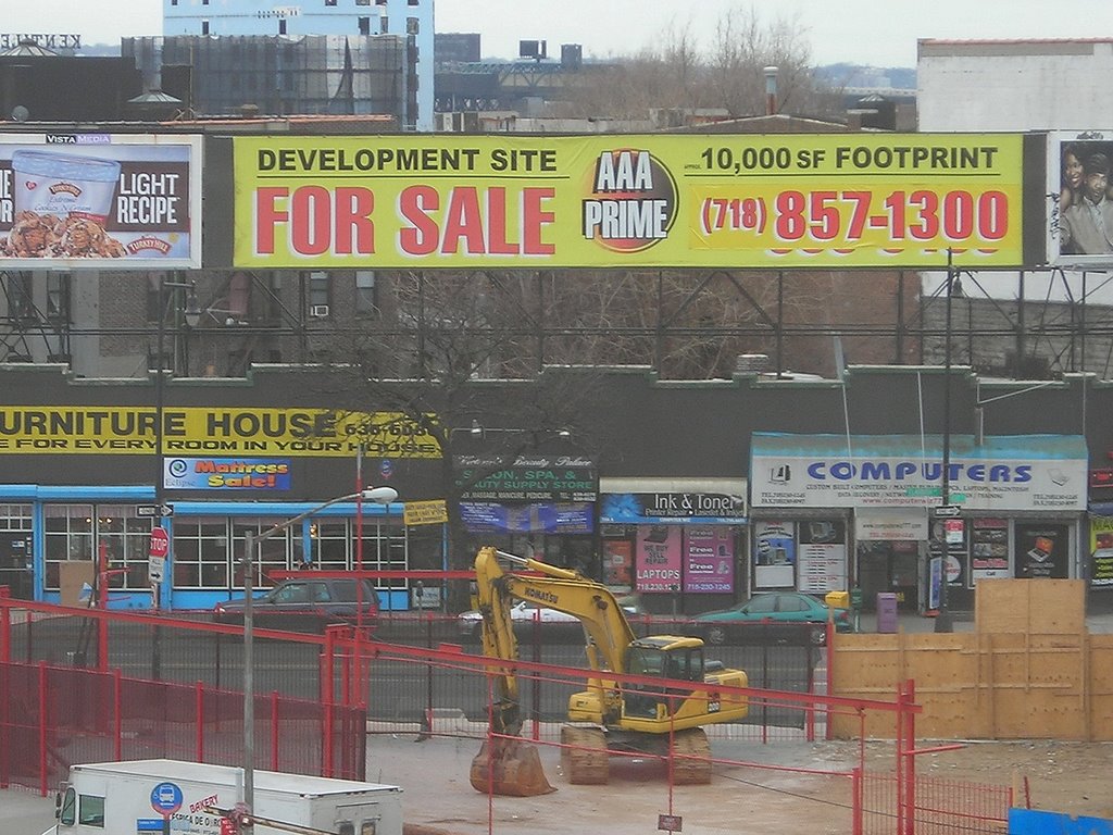
The photo at right shows another perspective on Flatbush Avenue, as well as the clearing of adjacent Block 1118 by Forest City Ratner. Note that it's an "AAA prime" "development site." (You can see the "Furniture House" sign in both this and the above photo.)
Punting on blight
The real question is who was responsible for the "unsanitary and unsafe conditions" among which people live.
As I wrote in November 2006, several people commented to the ESDC, saying the city and the Metropolitan Transportation Authority (MTA) should be blamed for failing to take care of the MTA's Vanderbilt Yard.
In response, the ESDC punted, ignoring the question of responsibility:
Chapter 1, “Project Description,” and Chapter 3, “Land Use, Zoning, and Public Policy,” describe in detail the present condition of the project site, including the Vanderbilt Yard.
 And what if the railyards, despite the designation as part of the Atlantic Terminal Urban Renewal Area, aren't actually blighted, as I wrote, but an active use--and, it should be added, a very valuable site for development.
Indeed, it is not "unsanitary" or "unsafe" conditions that lead to indicia of blight in the map above, but rather underutilization, as with this gas station. (Or are these cracks in the sidewalk unsafe?)
Comments
Post a Comment