Atlantic Ave. rezoning plan “community-led,” but first discussion omits recent spot rezonings & City Planning’s 17-story benchmark. Workshops start tonight.
The kickoff meeting of the Atlantic Avenue Mixed-Use Plan (AAMUP), held virtually 1/17/23, drew some 200 participants, but generated no press coverage beyond a report that night on PIX11, interviewing people outside in the neighborhood, as well as Council Member Crystal Hudson.
But the TV reporter didn’t sit through the two-hour-plus session on the future of “an inclusive, mixed-use stretch of Atlantic Avenue and neighboring blocks in Crown Heights and Bedford-Stuyvesant,” to quote the Department of City Planning.
After all, it's not easy to report thoroughly on a complicated, early-stage meeting, and the local press is ever diminished.
As the video below shows, and I’ll describe, the meeting included some interesting presentations, then discussions about the future the blocks east of Vanderbilt Avenue leading to Nostrand Avenue both north and south of Atlantic Avenue, which have been shackled by outdated manufacturing zoning.
Two key questions
Lubinsky said the planning process seeks to answer a couple of key questions in dialogue with the community.
The first is: how do we balance housing demand, affordability, and jobs?
The background is the rising cost of housing, increasing rent burden, and gentrification that has displaced lower-income residents.

But the TV reporter didn’t sit through the two-hour-plus session on the future of “an inclusive, mixed-use stretch of Atlantic Avenue and neighboring blocks in Crown Heights and Bedford-Stuyvesant,” to quote the Department of City Planning.
After all, it's not easy to report thoroughly on a complicated, early-stage meeting, and the local press is ever diminished.
 |
| From slideshow |
As the video below shows, and I’ll describe, the meeting included some interesting presentations, then discussions about the future the blocks east of Vanderbilt Avenue leading to Nostrand Avenue both north and south of Atlantic Avenue, which have been shackled by outdated manufacturing zoning.
But I was struck by a fundamental flaw in the claim that it’s “a community-led planning process" and the summary description, at left, regarding why this is happening now.
However public input is sought, some fundamental background to the plan, regarding past and pending spot rezonings--crucial to questions about potential bulk and potential affordability in future buildings-- was barely touched on.
What about the recent rezonings?
The plan was described by facilitator Adam Lubinsky of consultancy WXY as “the logical next step following years of work by local leaders and Community Board 8,” which has pursued an area rezoning known as M-CROWN, aiming to incentive affordable housing and local jobs.
However, while DCP shared documents that it had presented to Brooklyn Community Board 8 in response to the latter’s M-CROWN, there's barely any information on the AAMUP web site about the nine spot rezonings already approved in or near the district.
Nor was there any discussion of those spot rezonings.
That’s important because those private rezonings were encouraged and guided by DCP, which recommended 17-story developments along Atlantic Avenue, for example, while Community Board 8’s guidelines pointed to 14 stories.
Any discussion in the community-led plan needs to recognize the opportunities and the tradeoffs. One catalyst for the AAMUP was the two spot rezonings that Hudson agreed to in April, agreeing to greater density than CB 8 had sought, in exchange for more affordability: 35% of the units.
(Note: the documents memorializing that rezoning, which involve the nonprofit counter-parties Fifth Avenue Committee and IMPACCT Brooklyn, still haven’t been made public, though I got Hudson’s office to provide more details for my 12/8/22 City Limits article. That raises questions about transparency.)
A few weeks ago, I queried representatives of the AAMUP, as well as DCP and Hudson's office, about why the broader context was not shared, but I didn’t get a response. I did contact Kuhl, who shared the updated map above, and offered the following comment:
Planning sessions this week
This week marks another step forward, with three in-person meetings—tonight, Wednesday, and Thursday—to delve more deeply into the specific topics. (I am not sure whether they will be recorded.)
The plan, said Lubinsky, “will help shape what infrastructure projects to prioritize and inform the development of a formal land use or rezoning proposal.”
The goal is to have the community plan developed by June, which then would go through the city’s land-use review process next year. However, as suggested in the meeting by Bahij Chancey of WXY, it would be “likely another couple of years” before implementation.
The next major public meeting will be in March. After that will be more working group meetings, and a third public workshop to refine the draft recommendations. Then more working group meetings before the Steering Committee decides on final recommendations.
Consensus possible?
The facilitators at WXY were enthusiastic, with Chancey stating early on. “As a community plan, this process is not led by the Department of City Planning or by us as facilitators. We're here to ensure that you all have the right resources and the forum that your community needs to define your challenges and opportunities and come to consensus on solutions.”
Whether a consensus is possible—with or without more information—is in question. After all, some participants, reflecting YIMBY philosophy, argued for more and faster housing construction, even expanding the scope of the study area.
Others were more focused on other aspects of the plan, and/or support more modest development.
However public input is sought, some fundamental background to the plan, regarding past and pending spot rezonings--crucial to questions about potential bulk and potential affordability in future buildings-- was barely touched on.
What about the recent rezonings?
The plan was described by facilitator Adam Lubinsky of consultancy WXY as “the logical next step following years of work by local leaders and Community Board 8,” which has pursued an area rezoning known as M-CROWN, aiming to incentive affordable housing and local jobs.
 |
| From slideshow but not broadcast |
Nor was there any discussion of those spot rezonings.
Note: the slide presentation below does mention--as shown in the slide at right--seven private rezoning applications in CB 8 since 2019, but as far as I can tell, that slide, in the Appendix, was neither shown nor discussed at the meeting.
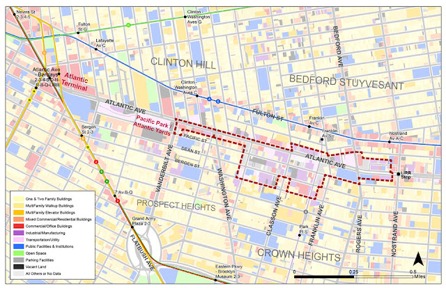
Moreover, no map, like the one below, created and updated by the urban planner Kaja Kühl (also a member of the AAMUP Steering Committee), was circulated.
Moreover, no map, like the one below, created and updated by the urban planner Kaja Kühl (also a member of the AAMUP Steering Committee), was circulated.
 |
| Map by Kaja Kühl. Rezoning in light blue pending. Potential apartment counts are from Environmental Assessment Statements and include areas beyond the parcels owned by applicants. |
That’s important because those private rezonings were encouraged and guided by DCP, which recommended 17-story developments along Atlantic Avenue, for example, while Community Board 8’s guidelines pointed to 14 stories.
Any discussion in the community-led plan needs to recognize the opportunities and the tradeoffs. One catalyst for the AAMUP was the two spot rezonings that Hudson agreed to in April, agreeing to greater density than CB 8 had sought, in exchange for more affordability: 35% of the units.
(Note: the documents memorializing that rezoning, which involve the nonprofit counter-parties Fifth Avenue Committee and IMPACCT Brooklyn, still haven’t been made public, though I got Hudson’s office to provide more details for my 12/8/22 City Limits article. That raises questions about transparency.)
A few weeks ago, I queried representatives of the AAMUP, as well as DCP and Hudson's office, about why the broader context was not shared, but I didn’t get a response. I did contact Kuhl, who shared the updated map above, and offered the following comment:
I look forward to seeing more background information like this to be mapped and visualized by the project team for the upcoming working group meetings in order to have an informed discussions about the goals of this plan. How do we redefine MIH [Mandatory Inclusionary Housing] or mixed use? Does the C train have extra capacity? What are the structural challenges of Atlantic Avenue? Where we can carve out open space? These discussions should be supported by a clear and comprehensive existing conditions analysis.It seems like a fundamental issue to provide more background information.
Planning sessions this week
This week marks another step forward, with three in-person meetings—tonight, Wednesday, and Thursday—to delve more deeply into the specific topics. (I am not sure whether they will be recorded.)
- Feb. 13: housing and income-restricted housing.
- Feb. 15: job creation and support services
- Feb. 16: the public realm and infrastructure needs, including open space and improvements to Atlantic Avenue and surrounding streets
The plan, said Lubinsky, “will help shape what infrastructure projects to prioritize and inform the development of a formal land use or rezoning proposal.”
The goal is to have the community plan developed by June, which then would go through the city’s land-use review process next year. However, as suggested in the meeting by Bahij Chancey of WXY, it would be “likely another couple of years” before implementation.
The next major public meeting will be in March. After that will be more working group meetings, and a third public workshop to refine the draft recommendations. Then more working group meetings before the Steering Committee decides on final recommendations.
Consensus possible?
The facilitators at WXY were enthusiastic, with Chancey stating early on. “As a community plan, this process is not led by the Department of City Planning or by us as facilitators. We're here to ensure that you all have the right resources and the forum that your community needs to define your challenges and opportunities and come to consensus on solutions.”
Whether a consensus is possible—with or without more information—is in question. After all, some participants, reflecting YIMBY philosophy, argued for more and faster housing construction, even expanding the scope of the study area.
Others were more focused on other aspects of the plan, and/or support more modest development.
(Several, by the way, mentioned Atlantic Yards as a cautionary tale, with sticky notes from the breakout sessions like “Please don't mirror Atlantic Yards” or “Barclays development—promise is left unmet.” See slideshow at bottom.)
Hudson, in her closing remarks, acknowledged that, based on her observation of the breakout room in which she participated, “we're not always going to agree on everything. There are a lot of diverse opinions and thoughts, perspectives, and also experiences.”
So, she said, what brings value is “making sure that we have everyone's perspective and lived experience included and taken into account.” That, of course, does not necessarily set the priorities, which, as I’ve noted, might be signaled by the "City of Yes" branding that suggests Mayor Eric Adams' encouragement building.
Early on, WXY’s Lubinsky described the process somewhat more candidly: the recommendations will “be shaped by the community and the Steering Committee that absorbs the community feedback.”
That Steering Committee, which notably does not include representatives of tenant groups—remember, the Crown Heights Tenant Union criticized Hudson for approving those spot rezonings—is likely to reflect, at least in part, allies of Hudson.
 |
| From slideshow |
Note the larger neighborhood context map above, with the quarter-mile buffer and half-mile buffer, which included some areas that participants said deserved attention and, perhaps, additional housing.
Regarding street design and transportation, at least the plan will extend west along Atlantic Avenue to Flatbush Avenue, thus encompassing the blocks bordering the Barclays Center and the Atlantic Yards/Pacific Park project.
 |
| From slideshow; note that "Not Burdened" means those not spending 30% or more of their income on rent |
Lubinsky said the planning process seeks to answer a couple of key questions in dialogue with the community.
The first is: how do we balance housing demand, affordability, and jobs?
The background is the rising cost of housing, increasing rent burden, and gentrification that has displaced lower-income residents.
So those behind the rezoning see an opportunity for permanently affordable housing.
The second is: “how do we transform Atlantic Avenue from a transportation artery to a thriving corridor for residents and businesses?”
Interestingly, those questions do not map directly the three working-group sessions.
Questions from the participants
The facilitators and organizers fielded several questions from the attendees, including:
Developing the focus areas
Before the group broke into smaller sections, Chancey presented posibilities regarding the three focus areas:
So in other neighborhoods, the city’s toolkit has, for example, included expanded sidewalks, medians, seatings, and plantings, or expanding a playground and community space.
Regarding economic development and workforce development as well as city services, tools include things like workforce development programs, health and wellness programs and services, early childhood programs, small business services and other city supported programs.
In other neighborhoods, the city has established the Northern Manhattan Arts and Culture Program or a Workforce1 Career Center.
Asked for priorities for community resources, the leading one was for housing and homelessness support. In terms of service space needs, participants cited after-school and youth programs, employment resources, job training, and small business/entrepreneurship support.
Land use questions
Regarding land use, density, and housing, Lubinsky pointed to a map that showed numerous vacant or underutilized lots.
 |
| From slideshow |
Interestingly, those questions do not map directly the three working-group sessions.
Questions from the participants
The facilitators and organizers fielded several questions from the attendees, including:
- how was the project area chosen? (based on previous work by Community Board 8 and DCP)
- what about the displaced? (Hudson said it was also aimed at future residents, but they could think about “refaming” some of the language)
- given that 1010 Pacific, a new building enabled by a spot rezoning, will have rents of $3,000 and up, how will new development support housing affordability? (Hudson said a top priority was deeply affordable housing; no one immediately pointed out that the rent cited reflects market-rate units, while the low-income “affordable” ones, though hardly cheap, are not as pricey: $1,576 to $2,002)
- does the plan have specific goals for housing production? (Hudson said the goals would be determined by the process)
- what can be done to maximize housing? (DCP’s Jonah Rogoff said they had no set target: “we're not trying to maximize housing everywhere, but be really thoughtful about particular blocks and corridors.”)
- is there any focus on remediating the environmental impact of Atlantic Avenue, including projects to curb flooding, air pollution, and excessive heat? (Chancey said they plan will address a more sustainable future)
- how engage those who might want to live in the neighborhood (Hudson said they’d done a “pretty good job at getting the word out” but were open to suggestions)
 |
| From slideshow |
Before the group broke into smaller sections, Chancey presented posibilities regarding the three focus areas:
- streetscape, physical infrastructure, and open space.
- economic development, human capital. and services
- land use, density and housing
So in other neighborhoods, the city’s toolkit has, for example, included expanded sidewalks, medians, seatings, and plantings, or expanding a playground and community space.
 |
| From slideshow |
In other neighborhoods, the city has established the Northern Manhattan Arts and Culture Program or a Workforce1 Career Center.
Asked for priorities for community resources, the leading one was for housing and homelessness support. In terms of service space needs, participants cited after-school and youth programs, employment resources, job training, and small business/entrepreneurship support.
Land use questions
 |
| From slideshow |
He noted that Hudson aimed to expand the M=CROWN vision to address more than land use, to go beyond CB 8 to the north side of Atlantic Ave., and to account for policy changes like the city’s Mandatory Inclusionary Housing, or MIH.
In East Harlem, public land was used to build a 100% affordable building, while in Gowanus, the rezoning prioritizes commercial mixed-use corridors with ground-floor requirements for small business use and active sidewalks.
In East Harlem, public land was used to build a 100% affordable building, while in Gowanus, the rezoning prioritizes commercial mixed-use corridors with ground-floor requirements for small business use and active sidewalks.
Not mentioned, however, was whether a neighborhood rezoning could capture more affordability than MIH--as in the recent spot rezonings--or any way to capture the enormous value from an upzoning. (See Gowanus, where speculation before the rezoning ran rampant. In response, see policies suggested by the Pratt Center for Community Development.)
Asked the priorities for affordability, 48% of attendees supported allowing larger buildings to construct more housing (which is, basically, city policy), nearly half supported regulating rent increases (that suggests extending rent-regulation to what advocates call good-cause eviction), and just over half suggested mandating that developers build affordable housing with capped rents.
About a third supported pairing affordable housing with market rate housing to encourage new construction—again, a city/state policy.
Only 64% supported identifying city-owned property to build 100% affordable housing, which seems like a no-brainer among city planners.
Those results struck me as hindered by a lack of information about the history of rezonings in the neighborhood, as well as about DCP’s policies.
Breakout groups
The format allowed participants to post virtual “sticky notes” on a whiteboard in the breakout rooms, as shown at bottom.
At about 1:36 of the video, the groups began to report back. Lubinsky, jumping in to summarize the first group (others reporting back were Steering Committee members), noted, “We had a lot of conversation about about the nature of of building scale—some people concerned about a higher-rise building, but some people offering that Atlantic Avenue was a really good opportunity for that.”
Of course--the devil is in the details.
Sharon Wedderburn, chair of CB 8’s Land Use Committee, reporting back on her breakout room, noted that one purpose of M-CROWN was to provide walk-to-work jobs for neighborhood residents, “and that's something. I think… that's being forgotten here.”
Among the sticky notes, for example, was a suggestion that the McDonald's lot at the southeast corner of Atlantic and Vanderbilt avenues “could be re-purposed for more efficient community use.”
Well, that was the subject of a contentious rezoning, known as 840 Atlantic Avenue, that has been stalled by litigation. But a much larger building has been approved.
Only in a few of the breakout rooms was there mention of tenant harassment, overcharges, and deed theft—the depredations of (some in) the real-estate industry that many are relying on to build their way out of the housing crisis.
More about the attendees
Some polls helped the group better understand each other. About 77% of the respondents live in the area, and about 20% work there.
About 27% had lived in the area for more than 20 years and 22% between ten and 20 years. That brings local expertise, of course, but it also means—as critics of longstanding structures for community input have pointed out—that the interests of future residents are harder to represent.
Most said they used Atlantic Avenue most often as a north-south crossing, then an east-west travel route.
About 25% of folks said they experience Atlantic Avenue every day and 45% about twice a week. Some 85% said they walked, while 46% took the subway. A notably large percentage—41%—said they used bikes or CitiBikes. Drivers were 31% of the group.
Half the group said they accessed open space outside the immediate neighborhood, and 31% within the neighborhood. (It wasn’t clear how many of the former are already outside the immediate neighborhood.)
About half said they were familiar with CB 8’s M-CROWN plans.
Resources
Below are the sticky notes. The AAMUP web page has several slide presentations that DCP has made to Community Board 8.
Comments
Post a Comment