 What's wrong with the Final Scope of Analysis for the proposed Atlantic Yards project released by the Empire State Development Corporation (ESDC)? A lot, notably a new plan for surface parking, an unwillingness to examine the traffic impact on major arteries such as the Brooklyn-Queens Expressway, and a time frame apparently chosen to accentuate claims of blight.
That's the conclusion of Develop Don't Destroy Brooklyn (DDDB), which yesterday issued a stinging press release headlined Ratner/ESDC "Atlantic Yards" Scope of Analysis Seriously Flawed, charging that "Developer Increases Project Size, Makes Hollow Claims and Ignores Community."
 While DDDB may be first out of the blocks, several of DDDB's criticisms are shared by other groups not identified as project opponents. Also, other elements of the Final Scope unmentioned by DDDB raise questions and point to areas in the Draft Environmental Impact Statement (expected by early June) that surely will be contentious.
The most basic criticism: the plan is some 600,000 square feet bigger than the designed announced in December 2003. It may sound redundant for DDDB to say that, but some press outlets still haven't pointed it out.
A big parking lot
It's less expensive to build a surface parking lot than an underground garage, and that's what FCR plans, at least for a while, even though such a parking plan hadn't been discussed with the community. ("Here we are opening ourselves up - tremendous transparency, for two years," Forest City Ratner VP Jim Stuckey told the New York Times in an article published 11/6/05.)
DDDB observed: The final scope says that there will be interim surface parking on the eastern (Vanderbilt Avenue) and northern (Atlantic Avenue) parts of the proposed site, through at least 2010. Turning that part of Prospect Heights into a parking lot for the foreseeable future is unacceptable.
Architect Jonathan Cohn commented, "This 'use' of the site could be in-place for some time. While the Phase I analysis year is 2010 and Phase II is 2016, schedules for large projects are notorious for being accurate only at the moment they are proposed." Eric McClure, Atlantic Yards campaign coordinator for Park Slope Neighbors, observed, "Even a small downturn in the housing market could change its status from 'interim' to 'permanent.'"
The study area: too small
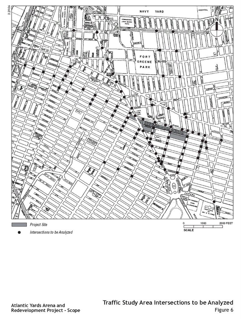
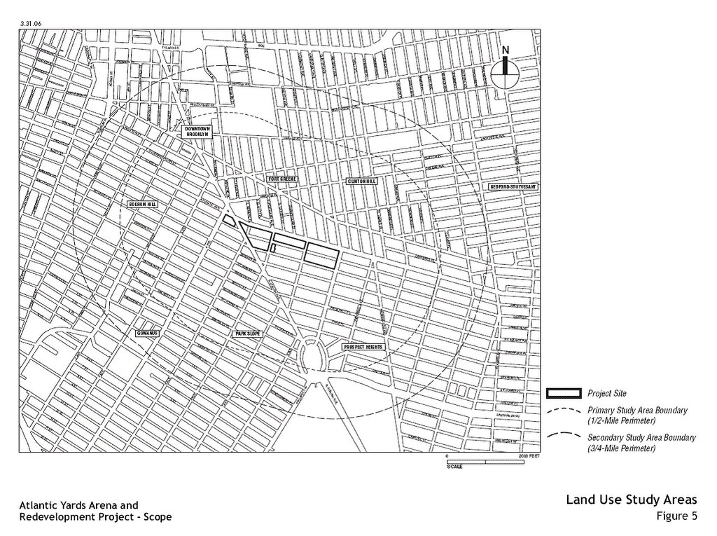 ESDC did agree to expand the study area, which had been criticized for its narrowness. The New York Times reported on 4/1/06: The development corporation also agreed to expand the main geographic area under study out to half a mile from the proposed project site, from the current quarter-mile, and increased from 65 to 93 the number of intersections where the traffic impact will be examined.
But the changes are unlikely to mollify the project's harshest critics.
 Indeed, ESDC continues to offer a strikingly narrow claim: that that "the study area was developed to account for the principal travel corridors to/from the site and is bounded on the north by Tillary Street/Park Avenue, on the south by Eastern Parkway/Union Street, on the east by Grand Avenue, and on the west by Hicks Street." (Emphasis added)
DDDB commented: The environmental review will not consider the traffic impact on the Brooklyn-Queens Expressway or the East River bridge crossings, despite the fact that the whole arena financial analysis by Dr. Andrew Zimbalist projects a substantial number of current New Jersey based fans to attend games. The BQE and the bridges should be included in the DEIS.
Others that had called for the study area for traffic to include the BQE and the East River crossings include the Municipal Art Society; the Council of Brooklyn Neighborhoods (CBN), which cited "all traffic arteries entering downtown Brooklyn"); and Community Boards 6 and 8. Not just the "harshest critics."
And while the ESDC agreed to expand the secondary study area for land use issues to three-quarters of a mile from a half-mile, the CBN had called for at least a one-mile study area. CB8 suggested analysis of all new development within two miles.
Time of analysis
In measuring the impact of traffic, the issue is not just location but time. In the Final Scope, ESDC states: The overall transportation impact analyses will also be performed for two phases. The first phase would be at completion of the arena and a portion of the mixed-use component in 2010 and the second phase would be at full completion of the project in 2016. The critical time periods for analysis will include the weekday 8:00-9:00 AM, noon-1:00 PM, 5:00-6:00 PM, 7:00-8:00 PM (pre-game) and 10:00-11:00 PM (post-game) periods as well as Saturday 1:00-2:00 PM (pregame) and 4:00-5:00 PM (post-game).
The Municipal Art Society, however, had called for a much broader range: Times for analysis should be expanded to peak traffic hours of 7-10 AM, 4:30 – 7:00 PM weekday for commercial and residential. Weekend Hours analyzed should be from 10-6 when most retail businesses are open, and traffic eastbound on Atlantic now backs up to 3rd Avenue or farther.
Also, CB6 called for an analysis of seasonal variations in traffic flow, citing congestion during the winter holiday season around the Atlantic Terminal and Atlantic Center malls, both adjacent to the project footprint.
Eminent domain
The Final Scope states that a major goal is the removal of blight: The overarching goal of the proposed project is to transform an area that is blighted and largely underutilized into a vibrant mixed-use community over a newly renovated rail yard with enhanced storage, increased inspection capacity, and improved functionality.
But how do you define blight? DDDB thinks the ESDC and FCR have rigged the game by choosing a later baseline date.
DDDB said: The scoping document uses February 2006 as a baseline date for the condition of the properties in the proposed footprint. The baseline date should be December 2003 when the proposal was unveiled, since which time Forest City Ratner has been purchasing, vacating warehousing and demolishing properties to create stagnation and "blight" conditions, which the ESDC will try to use to justify eminent domain. Without FCR and the proposal stagnating the neighborhood in the proposed footprint, development would be continuing apace with the surroundings. This baseline date must be changed for the DEIS.
Security & terrorism
Several commenters on the Draft Scope, include the CBN, called for an analysis of terrorism and security issues. But the ESDC early on said it wouldn't consider security.
DDDB said: The environmental review will not consider security and terrorism issues as related to the unique design, location and use of the proposal, as well as the financial impact of such prevention measures; this despite the debacle that occurred when such a pre-design analysis was left out of Ground Zero planning.
Real alternatives?
The Times article last Saturday observed: In a significant victory for critics of the project, the development corporation agreed to analyze three alternative proposals — including one from a rival developer, Extell Corporation — for developing the area, each of them with significantly lower density than the Forest City Ratner plan. However, the mayor and governor have already committed to the Forest City Ratner plan, and most Brooklyn officials are supporting it.
Also, ESDC head Charles Gargano has already endorsed the Atlantic Yards plan.
DDDB was skeptical: Though the final scope indicates that the environmental review will include three alternative plans, including the financially backed Extell Development Company community based plan, it remains to be seen as to what detailed extent the DEIS will analyze these plans versus the Ratner "Atlantic Yards" proposal.
DDDB added: The community requested that the final scope include an analysis of alternate locations for an arena (on top of the Atlantic Center Mall site, Coney Island, East New York, the Brooklyn Navy Yard) but this was ignored by the ESDC and FCR.
Police and fire
DDDB observed: The final scope document does not respond to this serious request from the community: "There must be a detailed analysis of the project’s impact on Engine Company 219/Ladder Company 1, at 494 Dean St., abutting the project site; and the 78th Precinct at 65 6th Avenue, less than two blocks from the site. The impact on these facilities, and their response times, during and after construction should be studied in detail, especially considering the nearby street closings and street widenings."
The debate here seems to be about what constitutes a "detailed analysis." The Final Scope, as opposed to the Draft Scope, did add sentences promising to "include assessment of the project's potential effect on FDNY/NYPD response times."
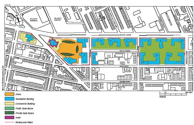
An open space sleight of hand?
The amount of open space created would be far too little for the number of new residents. If there's an adverse impact (such as the lack of open space) the Draft EIS will assess measures to mitigate that impact. The Final Scope seems to offer a solution: Other options may entail the expansion or upgrade of an existing community facility or open space resource.
Does that mean that, if Forest City Ratner agrees to improve some other parks or playgrounds in the area, it can make up for insufficient open space? In the ESDC's eyes, quite possibly. Maybe we should expect some really nice playgrounds in the Prospect Heights area.
Community benefits
The Final Scope offers a vague description of the Community Benefits Agreement:
To achieve many of the goals of the project’s purpose and need and to maximize the benefits to the local Downtown Brooklyn community, the project sponsors have coordinated and will continue to coordinate and consult with local community organizations. This effort has resulted in a Community Benefits Agreement between the project sponsors and eight community-based organizations addressing job training, affordable housing, community facilities, Minority- and Women-Owned Business Enterprise (MWBE) participation, and other items.
The CBN had requested far more details, mindful of the sketchy track record of several of the signatories:
Details of the Community Benefits Agreement should be provided, including full disclosure of the eight community-based organizations, when they were founded, their non-profit status, their track records in areas they are organizations and their directors with the project sponsors. The same information should be provided about other community-based organizations in the area that have expertise in the areas covered in the CBA but are not signatories.
Adding bikes
The ESDC, in the Final Scope, was partly responsive to comments that the Draft Scope ignored bicycles. The CBN had commented:
The EIS should include counts of bicycles at peak and off-peak hours, at least four times a year, along designated bicycle routes and streets with significant commercial activity, and project future demand for bicycle trips.
The Final Scope states: Identify existing and proposed bicycle facilities in the vicinity of the project site, including on-street bicycle lanes and bicycle routes identified in the City’s Bicycle Network Development program. Assess the potential effects on these bicycle facilities from new project travel demand and project-related changes to the street network;
Wind ignored
The CBN had asked that the Final Scope lay out the effects of wind:
Wind tunnel effects are already experienced in downtown Brooklyn and can cause problems for pedestrians, particularly people with impaired mobility. The EIS should study and measure wind tunnel effects caused by new construction, and the associated jobs will arise in proportion to the public cost.”
The Final Scope ignores this issue--as it does solar energy rights.
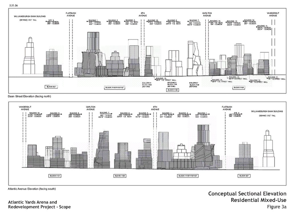
New view corridors and other tweaks
Though the project would create a superblock, with the closing of Pacific Street between Carlton and Vanderbilt avenues, the Final Scope adds a new planning principle, possibly a response to alternative plans that would have continued the street grid from Fort Greene: "Creation of visual and pedestrian corridors from Fort Greene going south into and through the proposed project’s open space and connecting surrounding neighborhoods." (Right)It doesn't seem all that different from the plan in the Draft Scope (below), except for some changes in the east side of the project.
 A close reading of the Final Scope turns up some other intriguing changes (emphases added):
--20-foot wide sidewalks, previously planned along the south side of Atlantic Avenue from Flatbush Avenue to Vanderbilt Avenue, would also be added along the east side of Flatbush Avenue between Atlantic Avenue and Dean Street, by setting the proposed buildings back from the street line
--while the Draft Scope promised "first-class commercial retail and office space," the Final Scope promises "neighborhood retail and first-class office space"
--while the Draft Scope said a goal was to "[e]liminate blighted conditions on the project site, including dilapidated and structurally unsound buildings, debris-filled vacant lots, and economically underutilized properties," the Final Scope eliminates the word "economically"
--while the Draft Scope said a goal was to "[c]ontribute to New York City’s effort to meet the short- and long-term demand for affordable and market-rate housing by providing... 4,500 rental units, 50 percent of which will be affordable to low- and moderate-income families," the Final Scope adds "middle-income families," an acknowledgement that the affordable housing would go to some families earning six figures
--the Final Scope amends a planning principle, which previously advocated "Utilization of sustainable design principles, where possible and reasonable" to "where possible and feasible"
--in the Final Scope, the ESDC, responding to concerns, agrees to consider views from beyond the 800-foot study area, such as the view from Grand Army Plaza along Flatbush Avenue
--in the Final Scope, the ESDC, responding to concerns, agreed to "discuss the project’s potential to result in increases in Combined Sewer Overflow (CSO) events, potential impacts on the Gowanus Canal Pumping Station, and the effect on water quality in the Gowanus Canal"
--the Draft Scope promised "the permanent closure of streets on the arena block and temporary bridge closures," but the Final Scope hints at an even broader impact: "the closure or partial closure of streets on, and surrounding, the project site, and temporary bridge closures."
Comments
Post a Comment