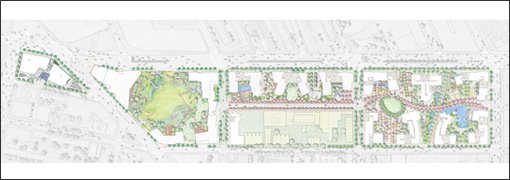
 Last April, I pointed out that the section on Open Space in the new Atlantic Yards.com web site deceptively claimed that the developer "will transform portions of the exposed rail yards into publicly accessible open space."
While portions of the rail yards would indeed become "publicly accessible open space," the phrasing suggests that the open space would be built only above the unsightly rail yards. Indeed, landscape architect Laurie Olin, in a candid interview with the New York Observer, explained how taking the street was crucial for Forest City Ratner to assemble the quota of open space necessary for the project to pass muster.
Taking the streets
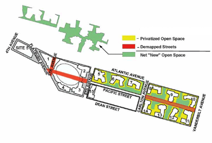 A comparison of Olin's sketch on the Atlantic Yards web site (above) with the schematic of the project footprint created by BrooklynSpeaks (right), shows that open space would be built over the currently functioning Pacific Street, as well as the area between Pacific and Dean streets currently occupied by buildings.
The Observer reported:
The design is far from finished, and the east end, where the superblock lies, is particularly rough. Mr. Olin admits that the site plan was put together to establish the parameters of the project—the ratio of open to built space—to go through the approval process.
Olin called streets "useless space"--a claim seized on by architect Jonathan Cohn and BrooklynSpeaks.
Indeed, the streets--and part of the project's southeast superblock--are clearly crucial to creating the open space that the developer, on AtlanticYards.com, attributes to the rail yards.
Comments
Post a Comment