 |
| From New York Times; Pacific Park shadows not delinated |
The interactive map is based on slightly stale data. So "every building" does not include recently erected Atlantic Yards/Pacific Park towers or their shadows, much less the shadows long predicted on buildout. Rather, the project footprint comes off as a smudge, as shown in the screenshot at right.
But the article did send me back a decade to recall the estimates of the significant shadows that project buildings are predicted to cast.
Not only will those shadows darken the much-hyped "park," they will extend past the footprint. Remember, the architect of the ten-story Atlantic Terrace building just northeast of the arena block scrapped plans for solar panels, saying in 2007, "It’s just not an option for a building that will be in substantial shade all year round."
The 2006 visuals
 Take for example the image at left of the project's Phase 2, east of Carlton Avenue, produced in 2006 for the Council of Brooklyn Neighborhoods (CBN), a coalition set up to respond to the environmental review.
CBN noted that, while state document portrayed the planned open space as green and unsullied by shadows, a shadow analysis suggested that in March, there wouldn't be much sun. (That also applies to September, six months later.) December is far worse, June much better.
And, as I'll describe further below, the language in the November 2006 Final Environmental Impact Statement (Final EIS) regarding shadows is vague and hedging, leaving it impossible to know just how much space would out of shadow and for how long.
However, Chapter 9 of the Final EIS, on Shadows, offers a seemingly un-rebuttable defense of shadows:
Were it not for the development of these buildings, this publicly accessible space would not be created. Therefore, the shadows on this public space would not be considered significant adverse impacts.
 |
| Promotional image, shadowless, from project web site |
On the other hand, shouldn't the developers touting "Pacific Park" maybe acknowledge the shadows? Oh, no. That would hurt sales.
But maybe those who rhapsodized about the Atlantic Yards open space--remember the Rev. Herbert Daughtry's expansive invocation at the March 2010 groundbreaking, citing "blooming flowers, and decorative fountains of spouting water"--might have second thoughts.
The warning in the Times
A key passage in the Times article should serve as a warning:
But [architect and consultant] Mr. [Michael] Kwartler doesn't think the solution needs to be so binary. Sunlight can be saved if developers and planners grow more sensitive to how buildings are oriented. The biggest enemy of parks, and especially small parks near new development in Brooklyn, says Mr. Kwartler, is bulky buildings to the south end of parks. He says that much of the loss of sunlight in our public parks could be avoided if our tall, bulky buildings were simply positioned to the north, west or east side.(Emphases added throughout)
Well, there will be four tall, bulky buildings along the southeast block of Pacific Park Brooklyn, furthering shadows on the public space--not a park--that's been so highly touted.
 |
| The bookend buildings on the southeast block, B11 (550 Vanderbilt) and B14 (535 Carlton) are under construction |
Looking at the shadow studies
 Chapter 9 of the 2006 FEIS explains, in part, how the open space is calculated to avoid shadows. But the winter is pretty much a disaster--as the state study showed, that long shadows at 9 am in the cold month of December not only cover the open space, but also large portions of Fort Greene.
The actual impact, according to the state, is not very clear:
The proposed project’s publicly accessible open space is designed to take into account the location and heights of the proposed buildings and the shadows they would create. Major landscape elements, such as the oval lawn, primary pathways, and water features, would be located to receive the maximum exposure to midday sun throughout the year. The location of other landscape elements, such as the north-south pathways and smaller passive use areas, would be sited and oriented to receive sunlight when other areas of this open space are in shade so that sizable portions of the entire open space would have access to sunlight during the late morning through early afternoon hours. The proposed project’s publicly accessible open space would receive shadow from Buildings 3 through 15 throughout the day in each analysis period. The incremental shadow would be greatest in the early mornings, when the shadows would stretch east and late afternoons, when the shadows would stretch west along the open space. During those times, most of the open space would be in shadow. Shadow is not generally expected to adversely affect active recreational uses such as volleyball, bocce, and the half basketball courts. The shadow would diminish the attractiveness of the passive recreation areas to their potential users.Ok, but what are "sizable portions"? Is that 20%, or 40%, or 70%?
And couldn't "late morning through early afternoon" be a rather brief period? Both of those descriptions have some flex in them, and could mean rather limited amounts.

The state analysis, as shown in the various shadow diagrams below, does not assess Fort Greene to the same extent.
And, of course, there are many more towers along/near Flatbush Avenue today, casting additional shadows. But it is clear, even from the state analysis, that the Atlantic Yards/Pacific Park open space will not be a sunny meadow.
Shifting shadows
The chapter offers this assessment on impacts, explaining that, the sun casts longer shadows in the early morning, and that winter sun, which is lower in the sky, casts longer shadows. And while summer shadows are the shortest, the sun travels farther, so summer sun "casts shadows in more directions than those seen in other seasons, and its late sunset and early sunrise creates shadows earlier in the morning and later in the evening than in other seasons."
[Note: the images below are blended from the Draft EIS and Final EIS in part because not all the images from the latter are available online. Not all the images from the Draft EIS were available either, so I later copied some images from a disc.]
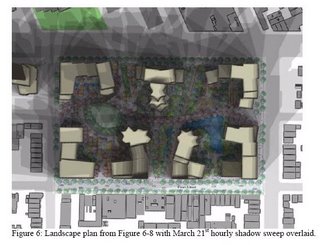
The shadows in March and September
MARCH 21/SEPTEMBER 21—ANALYSIS PERIOD: 7:36 AM TO 4:29 PM EST
At the beginning of the analysis period, almost all of the proposed project’s open space would be in shadow cast from Buildings 5 through 15 (see Figure 9-44). Throughout the day, these buildings would cast shadow on the new, adjacent open spaces. However, from 9:00 AM to 3:00 PM, large portions of the open spaces would be in full sun (see Figures 9-45 through 9-47). These open spaces would be covered in shadow again at the end of the analysis period (see Figure 9-48).As far as I can tell, large portions would not be in full sun, either.


The shadows in May and August
MAY 6/AUGUST 6—ANALYSIS PERIOD: 7:27 AM TO 6:18 PM DST
At the beginning of the analysis period, almost all of the project-created publicly accessible open space would be in shadow cast by Buildings 5 through 15 (see Figure 9-49). Throughout the day, these buildings would cast shadow on the new, adjacent open spaces. However, from 10:00 AM to 4:45 PM, large portions of the open spaces would be in full sun (see Figures 9-50 through 9-52). At the end of the analysis period, the open spaces would be covered in shadow again (see Figure 9-53).Well, during that time, large portions would not be in full sun, either.


The shadows in June
JUNE 21—ANALYSIS PERIOD: 6:57 AM TO 7:01 PM DST
Buildings 5 through 14 would cast almost all of the project-created publicly accessible open space in shadow at the beginning of the analysis period (see Figure 9-54). The adjacent open space would receive shadow throughout the day from these buildings. However, from 10:00 AM to 5:00 PM large portions of the open space would be in full sun (see Figures 9-55 through 9-57). When the analysis period ends the open spaces would be covered in shadow again (see Figure 9-58).Well, large portions would not be in full sun, either. And it looks pretty shady by 4:15 pm, actually.


The shadows in December
DECEMBER 21—ANALYSIS PERIOD: 8:51 AM TO 2:53 PM EST
Early in the analysis period, almost all of the project-created publicly accessible open space would be in shadow cast mainly by Buildings 5 through 14 (see Figures 9-59 and 9-60). Throughout the day, these buildings would cast shadow on the adjacent, new open spaces, but there would be some areas of sun in the midday (see Figures 9-61 through 9-62). At the end of the analysis period, these open spaces would again be covered in shadow (see Figure 9-63).Yes, there would be "some areas of sun." Sure. Just not very many.


Comments
Post a Comment